InfoGraphic: The Big Picture for Thursday / Friday
13/02/2019 6:25pm

> From the WeatherWatch archives
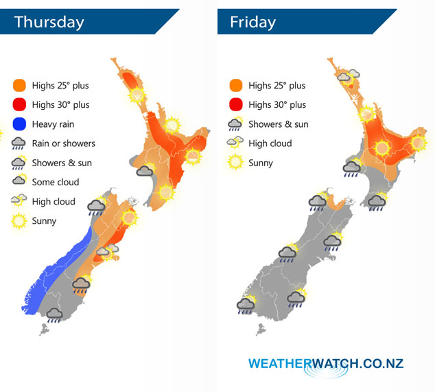
A cold front moves northwards over the South Island today meanwhile conditions are mainly settled further north. This front continues over the North Island on Friday but in a much more weakened state, meanwhile another front lines up the lower South Island.
Mostly sunny for the North Island today, some morning cloud in the southwest. Heavy rain pushes northwards along the West Coast of the South Island during the day, clearing at night. Rain moves into Southland during the morning with a southwest change, moving up to Banks Peninsula by evening although easing to showers by then. Sunny for Nelson and Marlborough.
Mostly sunny for the upper North Island on Friday, later in the evening some cloud and the risk of a shower moves in from Northland down through to the Waikato. A few morning showers from Taranaki through to Kapiti then sunny areas break through from afternoon. Sunny along the east coast although a shower or two is likely in the afternoon for Wairarapa. Any early showers clear the upper South Island then conditions brighten up, Marlborough may see cloud hang around for the majority of the day however. Some rain moves through Southland in the afternoon then Otago in the evening. Rain moves into Fiordland during the afternoon then pushes northwards reaching North Westland later in the evening.
By Weather Analyst Aaron Wilkinson – WeatherWatch.co.nz
Latest Video

Cold weekend, frosts return with high pressure, then a low late next week
The subantarctic airflow spreads over NZ today/tonight and into Saturday, dropping temperatures nationwide. Snow flurries are possible today to lower…
Related Articles
Cold weekend, frosts return with high pressure, then a low late next week
The subantarctic airflow spreads over NZ today/tonight and into Saturday, dropping temperatures nationwide. Snow flurries are possible today to lower…

Wintry burst of weather: Snow, squally showers then sunshine & frosts
A polar change (another one!) arrives on Friday for the South Island and goes nationwide on Saturday, leaving NZ under…

Antarctic southerly for parts of NZ Fri & Sat
For the first time this year a southerly from off Antarctica is heading towards the South Island, followed by more…

