InfoGraphic: The Big Picture for Thursday / Friday
21/11/2018 6:00pm

> From the WeatherWatch archives
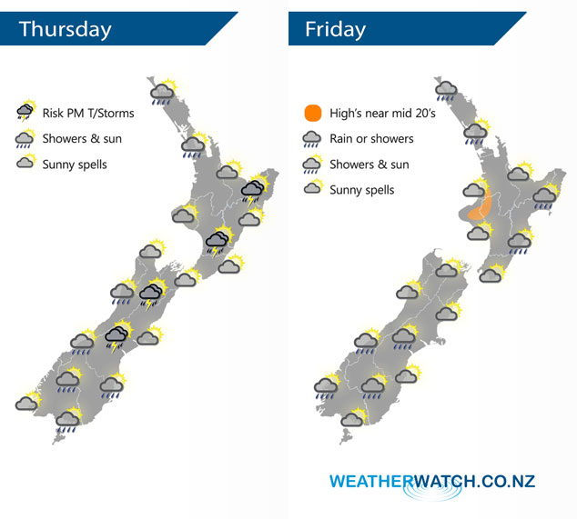
A weak broad area of low pressure brings a mixed bag of weather to New Zealand today. A low pressure system brews away in the Tasman Sea on Friday meanwhile a northeasterly airflow develops over New Zealand.
A few showers about Northland and Auckland gradually ease today then clearing early afternoon for most, a chance one or two may linger through till evening. Mainly dry elsewhere to start the day for the North Island then isolated showers develop during the afternoon about the eastern ranges, some may become heavy with thunderstorms then clearing later on. A dry morning for most of the South Island however expect some rain about Mid / South Canterbury, Otago and perhaps Southland. Isolated showers develop in the afternoon about inland areas (about the high country / main divide), some becoming heavy with a risk of thunder then clearing later in the day.
A mainly dry for most of the North Island on Friday, a few showers move into Northland in the evening then spreading to Auckland by midnight. There may also be an early clearing shower along the east coast. A mix of sun and cloud for most of the South Island, a few isolated showers possible about inland areas (about the high country) late afternoon / evening then clearing. Showers move into South Westland later in the evening or overnight.
By Weather Analyst Aaron Wilkinson – WeatherWatch.co.nz
Latest Video

Cold weekend, frosts return with high pressure, then a low late next week
The subantarctic airflow spreads over NZ today/tonight and into Saturday, dropping temperatures nationwide. Snow flurries are possible today to lower…
Related Articles
Cold weekend, frosts return with high pressure, then a low late next week
The subantarctic airflow spreads over NZ today/tonight and into Saturday, dropping temperatures nationwide. Snow flurries are possible today to lower…

Wintry burst of weather: Snow, squally showers then sunshine & frosts
A polar change (another one!) arrives on Friday for the South Island and goes nationwide on Saturday, leaving NZ under…

Antarctic southerly for parts of NZ Fri & Sat
For the first time this year a southerly from off Antarctica is heading towards the South Island, followed by more…

