InfoGraphic: The Big Picture for Thursday / Friday
21/02/2018 6:00pm

> From the WeatherWatch archives
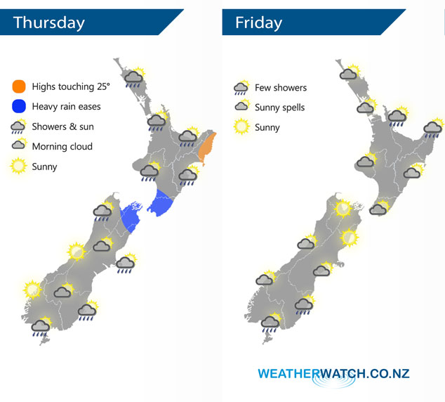
A low moves over the North Island today while southwesterlies ease further south. A southwesterly airflow continues over most of New Zealand on Friday, moving around a large high in the Tasman Sea.
Most North Island regions will see showers today, easing mid to late afternoon in the west and sunny areas then developing. In the east conditions are dry at first then showers push northwards with a southwest change. Early rain about central New Zealand which may be heavy eases.
Morning showers about the lower South Island and some eastern coastal areas clears then drying out in the afternoon, a shower or two may linger about outer parts of Banks Peninsula till evening. Sunnier conditions during the day along the West Coast. Morning cloud for inland areas breaks away.
A mix of sun and cloud for much of the North Island on Friday, a few showers may spring up late afternoon / evening from Coromandel across to East Cape. Mainly dry for the South Island however a few showers about Southland spread into parts of Otago late afternoon / evening.
By Weather Analyst Aaron Wilkinson – WeatherWatch.co.nz
Latest Video

Frosts, late week rain & another cold weekend coming
High pressure will cross NZ over the next few days meaning more cold nights/mornings with frosts, but a nor’wester will…
Related Articles
Frosts, late week rain & another cold weekend coming
High pressure will cross NZ over the next few days meaning more cold nights/mornings with frosts, but a nor’wester will…

NZ: Cold & windy, then calm & frosty
Downpours, some squally with the chance of thunderstorms and even small tornadoes are possible for parts of NZ over Friday…

WeatherWatch App launches real-time local lightning tracker
A bolt out of the blue! WeatherWatch has launched a live, real-time lightning tracker, enabling Kiwis to gain access to data provided by the…

