InfoGraphic: The Big Picture for Thursday / Friday
24/10/2018 6:00pm

> From the WeatherWatch archives
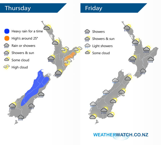
A front bringing in a cool change and some rain pushes northwards over the South Island during today, reaching the lower North Island this evening. This front breaks up over the North Island on Friday as it moves northwards, anticyclonic conditions building elsewhere.
Dry for the upper North Island today, cloud increases during the day with northwesterly winds. Mostly cloudy for the lower western North Island, chance of a shower then rain moves in later in the evening / overnight with the chance of heavy falls. Mostly sunny in the east, rain moves into the Wairarapa this evening then northwards overnight. A wet day for a majority of the South Island, some heavy rain too for a time, mainly about the main divide and along the West Coast. Nelson and Marlborough is mainly dry till late afternoon / evening then rain moves in.
Morning showers clear for most of the western North Island then sunny areas increase with southeasterly winds, the odd shower may hang about Northland through till evening. Early rain along the east coast eases to showers then long dry spells developing from afternoon, winds cool from the south. Mostly cloudy for the West Coast of the South Island, chance of a light shower or two especially about Buller. Cloudy areas and occasional sun elsewhere, chance of an isolated shower late afternoon / evening about inland Otago.
By Weather Analyst Aaron Wilkinson – WeatherWatch.co.nz
Latest Video

NZ: 8 Day outlook as gales & rain ease, high pressure builds
Damaging wind gusts and heavy rain will continue to affect some parts of the North Island and brushing Marlborough today…
Related Articles
NZ: 8 Day outlook as gales & rain ease, high pressure builds
Damaging wind gusts and heavy rain will continue to affect some parts of the North Island and brushing Marlborough today…

Pockets of hit & miss heavy rain, snow moves northwards
Low pressure continues to slowly move across the upper North Island and for some that will bring the sun out,…

Slow go for northern low & southern cold
For the next few days low pressure will crawl over the upper North Island, driving in rain as far south…

