InfoGraphic: The Big Picture for Thursday / Friday
8/08/2018 7:31pm

> From the WeatherWatch archives
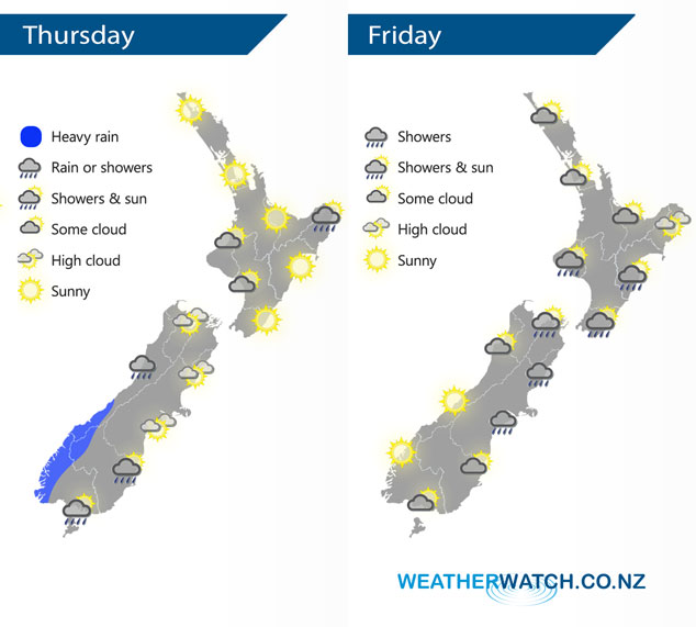
A westerly quarter airflow lies over New Zealand today, moving around a high sitting in the north Tasman Sea. Around midday a front moves onto the lower South Island. A high lies over over New Zealand on Friday with a weak front about central areas.
Mostly sunny for much of the North Island today, just a few clearing morning showers for East Cape. Some cloud at times in the west south of Taranaki may deliver a light shower or two, mainly this morning. For the South Island, rain pushes onto South Westland from midday with heavy falls developing. Mainly dry in the east with some high cloud. A few spots of rain possible about Southland and Otago, showers then move through for a time in the evening with a southwest change.
A mix of sun and cloud for the upper North Island on Friday, dry with light southwesterly winds. A mainly sunny morning in the east then cloud develops in the afternoon with the chance of a shower as light winds tend southerly. A few light showers possible from afternoon in the west also Taranaki southwards. A few showers affect Canterbury northwards in the south Island, easing from afternoon. Sunnier conditions further south with any morning cloud about Southland and Otago breaking away.
By Weather Analyst Aaron Wilkinson – WeatherWatch.co.nz
Latest Video

Cold weekend, frosts return with high pressure, then a low late next week
The subantarctic airflow spreads over NZ today/tonight and into Saturday, dropping temperatures nationwide. Snow flurries are possible today to lower…
Related Articles
Cold weekend, frosts return with high pressure, then a low late next week
The subantarctic airflow spreads over NZ today/tonight and into Saturday, dropping temperatures nationwide. Snow flurries are possible today to lower…

Wintry burst of weather: Snow, squally showers then sunshine & frosts
A polar change (another one!) arrives on Friday for the South Island and goes nationwide on Saturday, leaving NZ under…

Antarctic southerly for parts of NZ Fri & Sat
For the first time this year a southerly from off Antarctica is heading towards the South Island, followed by more…

