InfoGraphic: The Big Picture for Thursday / Friday
6/06/2018 7:00pm

> From the WeatherWatch archives
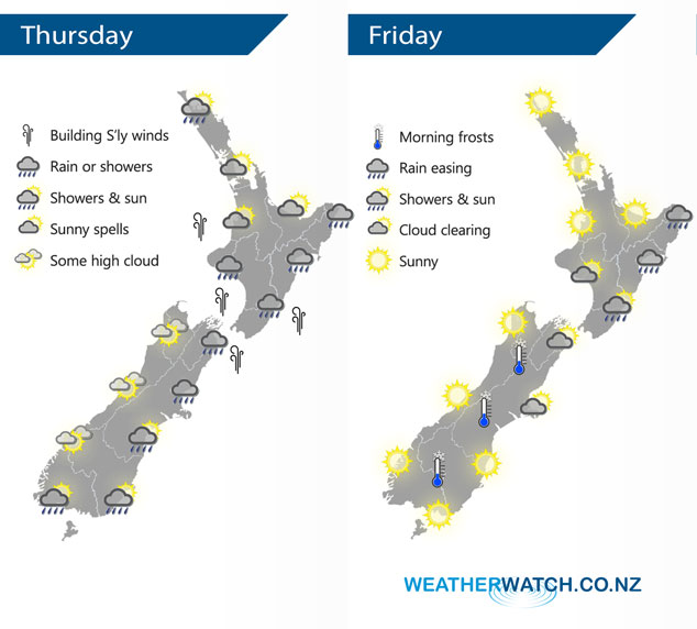
A large high sits in the Tasman Sea today directing a southwesterly airflow over New Zealand, a warm front pushes northwards over the country during the day. A ridge of high pressure pushes over the South Island early in the morning on Friday then gradually spreads onto the North Island later in the day.
A shower or two for the upper North Island today, many long dry areas also especially in the east. Showers more prevalent for the lower North Island, a period of rain moves through this afternoon then eases in the evening. Rain may not move into Hawkes Bay and Gisborne till evening. Some snow about the Central Plateau down to 600m for a time.
Southerlies about the lower North Island build from afternoon, rising to gale about some coastal areas.
Mostly sunny along the West Coast of the South Island, just some high cloud. In the east expect a period of rain this morning for Canterbury and Marlborough then easing this afternoon, just a shower or two expected about Southland and Otago.
Morning rain for the eastern North Island eases to showers then gradually clearing away on Friday, mainly sunny elsewhere. The South Island has a sunny day also, just some morning cloud in the northeast then clearing.
By Weather Analyst Aaron Wilkinson – WeatherWatch.co.nz
Latest Video

Cold weekend, frosts return with high pressure, then a low late next week
The subantarctic airflow spreads over NZ today/tonight and into Saturday, dropping temperatures nationwide. Snow flurries are possible today to lower…
Related Articles
Cold weekend, frosts return with high pressure, then a low late next week
The subantarctic airflow spreads over NZ today/tonight and into Saturday, dropping temperatures nationwide. Snow flurries are possible today to lower…

Wintry burst of weather: Snow, squally showers then sunshine & frosts
A polar change (another one!) arrives on Friday for the South Island and goes nationwide on Saturday, leaving NZ under…

Antarctic southerly for parts of NZ Fri & Sat
For the first time this year a southerly from off Antarctica is heading towards the South Island, followed by more…

