InfoGraphic: The Big Picture for Thursday / Friday
16/05/2018 7:00pm

> From the WeatherWatch archives
A southwesterly airflow lies over New Zealand today with a front pushing onto the lower South Island this afternoon. A westerly airflow lies over New Zealand on Friday, a disturbance in the Tasman Sea moves onto the upper South Island later in the afternoon or evening then onto the lower North Island overnight bringing some rain.
Showers for most North Island regions today, especially in the west.
The same goes for the South Island although after any early morning showers clear the east coast experiences a mainly dry afternoon. A frosty start for inland parts of the lower South Island. Rain moves into South Westland this afternoon, pushing northwards in the evening although this area of rain gradually weakens.
Showers for western parts of the North Island on Friday, sunnier out east. Some rain moves onto the lower North Island in the west south of Taranaki and for Wellington overnight.
Showers for the West Coast of the South Island and for Southland, only the chance of a shower for Otago otherwise mainly dry. Sunny weather for Canterbury and Marlborough for much of the day. Later in the afternoon some rain moves into Buller, spreading into Nelson and Marlborough later in the evening before clearing overnight.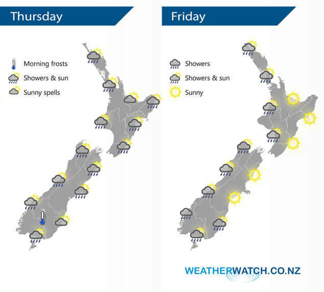
By Weather Analyst Aaron Wilkinson – WeatherWatch.co.nz
Latest Video

Cold weekend, frosts return with high pressure, then a low late next week
The subantarctic airflow spreads over NZ today/tonight and into Saturday, dropping temperatures nationwide. Snow flurries are possible today to lower…
Related Articles
Cold weekend, frosts return with high pressure, then a low late next week
The subantarctic airflow spreads over NZ today/tonight and into Saturday, dropping temperatures nationwide. Snow flurries are possible today to lower…

Wintry burst of weather: Snow, squally showers then sunshine & frosts
A polar change (another one!) arrives on Friday for the South Island and goes nationwide on Saturday, leaving NZ under…

Antarctic southerly for parts of NZ Fri & Sat
For the first time this year a southerly from off Antarctica is heading towards the South Island, followed by more…

