InfoGraphic: The Big Picture for Thursday / Friday
25/03/2020 10:00pm
> From the WeatherWatch archives
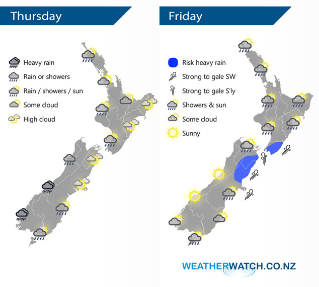
A westerly quarter airflow lies over New Zealand today, a cold southwest change hits the lower South Island this morning moving northwards to reach the lower North Island overnight. This front pushes over the North Island on Friday meanwhile a ridge of high pressure starts to sneak in over the lower South Island.
The odd shower continues at times for the western North Island today, expect plenty of dry spells. Dry in the east. Heavy rain moves into Fiordland this morning reaching North Westland in the afternoon, easing overnight. Rain pushes into Southland late morning reaching Otago in the afternoon and Canterbury in the evening with a fresh southwest change. Overnight rain may become heavy about inland Canterbury.
Most North Island regions see rain or showers on Friday, rain may become heavy about Wellington / Wairarapa in the evening as southerlies freshen. Mostly sunny for the West Coast of the South Island however there may be early showers about North Westland then clearing away. Cloudy areas for Southland / Otago. Rain for Canterbury, Marlborough and Nelson eases from the south. Heavy falls about Marlborough clear away in the evening.
By Weather Analyst Aaron Wilkinson – WeatherWatch.co.nz
Latest Video

Slow go for northern low & southern cold
For the next few days low pressure will crawl over the upper North Island, driving in rain as far south…
Related Articles
Slow go for northern low & southern cold
For the next few days low pressure will crawl over the upper North Island, driving in rain as far south…

Slow moving low to track over northern NZ
A low pressure zone will slowly cross the North Island over the coming days, bringing hit and miss pockets of…

NI low pressure, SI polar change
Low pressure will move over the upper North Island this week, bringing hit and miss pockets of heavier rain into…

