
> From the WeatherWatch archives
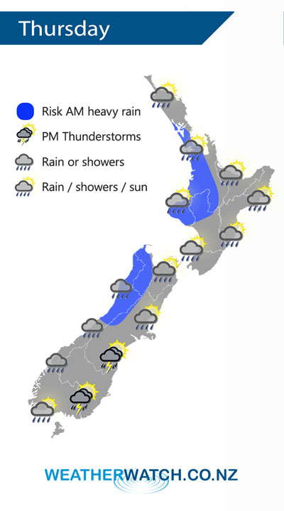
A cold front moves off the North Island away to the northeast on Thursday afternoon, meanwhile an area of low pressure moves onto the South Island bringing potentially unstable conditions in the southeast after midday.
Morning rain with a chance of heavy falls in the west for the North Island on Thursday then clearing with sunny areas developing, later in the evening showers move back in again. Morning high cloud along the east coast with some rain spreading from the west at times then becoming mostly sunny in the afternoon.
Early morning heavy rain eases about North Westland to showers, showers elsewhere along the West Coast then rain moves in again during the afternoon. The east coast is largely dry although the odd shower is possible, morning showers about Canterbury then clearing away. During the afternoon showers become heavy with a risk of thunder / hail from Southland through to South Canterbury in the east then clearing at night.
By Weather Analyst Aaron Wilkinson – WeatherWatch.co.nz
Latest Video

NZ: 8 Day outlook as gales & rain ease, high pressure builds
Damaging wind gusts and heavy rain will continue to affect some parts of the North Island and brushing Marlborough today…
Related Articles
NZ: 8 Day outlook as gales & rain ease, high pressure builds
Damaging wind gusts and heavy rain will continue to affect some parts of the North Island and brushing Marlborough today…

Pockets of hit & miss heavy rain, snow moves northwards
Low pressure continues to slowly move across the upper North Island and for some that will bring the sun out,…

Slow go for northern low & southern cold
For the next few days low pressure will crawl over the upper North Island, driving in rain as far south…

