InfoGraphic: The Big Picture for Saturday / Sunday
21/02/2020 2:00am

> From the WeatherWatch archives
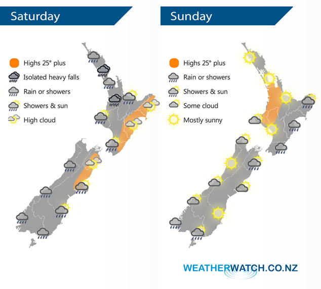
A series of fronts push northwards over New Zealand on Saturday in a southwesterly airflow. A ridge spreads over New Zealand on Sunday stretching out from an anticyclone in the Tasman Sea.
Some morning rain for the upper North Island on Saturday then easing to showers in the afternoon, showers may become heavy with thunderstorms in the afternoon for Northland and Bay Of Plenty then easing in the evening. Northwesterlies change southwest. Morning showers in the southwest then dry spells increasing from afternoon. Mainly dry in the east with some high cloud, late afternoon / evening a southwest change brings a few showers. Some morning rain for the West Coast of the South Island then easing to showers, mostly clearing evening. Showers about Southland and Otago spread northwards into Canterbury during the afternoon with a southerly change. There may be some rain about inland Canterbury from evening then easing overnight.
Mostly sunny for the western North Island on Sunday, showers in the east due to a southeasterly airflow. Morning showers clear Marlborough then mostly sunny, mostly sunny for the rest of the South Island after any morning cloud clears. Fiordland sees the odd shower at the other end of the country, Southland is mainly dry but there is the chance of a coastal shower.
By Weather Analyst Aaron Wilkinson – WeatherWatch.co.nz
Latest Video

Cold weekend, frosts return with high pressure, then a low late next week
The subantarctic airflow spreads over NZ today/tonight and into Saturday, dropping temperatures nationwide. Snow flurries are possible today to lower…
Related Articles
Cold weekend, frosts return with high pressure, then a low late next week
The subantarctic airflow spreads over NZ today/tonight and into Saturday, dropping temperatures nationwide. Snow flurries are possible today to lower…

Wintry burst of weather: Snow, squally showers then sunshine & frosts
A polar change (another one!) arrives on Friday for the South Island and goes nationwide on Saturday, leaving NZ under…

Antarctic southerly for parts of NZ Fri & Sat
For the first time this year a southerly from off Antarctica is heading towards the South Island, followed by more…

