InfoGraphic: The Big Picture for Saturday / Sunday
20/04/2018 7:53pm

> From the WeatherWatch archives
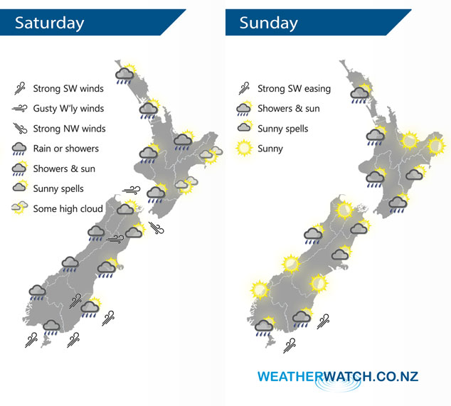
A blustery west to southwesterly airflow lies over New Zealand on Saturday, easing on Sunday as a ridge starts to push in extending out from a high in the Tasman Sea.
Rain or showers for western and southern parts of the country on Saturday, a southwest change brings a few showers up into Canterbury during the afternoon. Winds from the west or southwest will be quite blustery for many parts of the South Island and lower North Island, winds will likely be strongest about coastal areas but some inland parts of the South Island will see gusty winds also.
Showers are mainly only around in the morning for parts of New Zealand on Sunday then drying out into the afternoon. Conditions becoming calmer for most with winds easing and sunny areas increasing.
By Weather Analyst Aaron Wilkinson – WeatherWatch.co.nz
Latest Video

NZ: 8 Day outlook as gales & rain ease, high pressure builds
Damaging wind gusts and heavy rain will continue to affect some parts of the North Island and brushing Marlborough today…
Related Articles
NZ: 8 Day outlook as gales & rain ease, high pressure builds
Damaging wind gusts and heavy rain will continue to affect some parts of the North Island and brushing Marlborough today…

Pockets of hit & miss heavy rain, snow moves northwards
Low pressure continues to slowly move across the upper North Island and for some that will bring the sun out,…

Slow go for northern low & southern cold
For the next few days low pressure will crawl over the upper North Island, driving in rain as far south…

