InfoGraphic: The Big Picture for Saturday / Sunday
25/10/2019 2:00am

> From the WeatherWatch archives
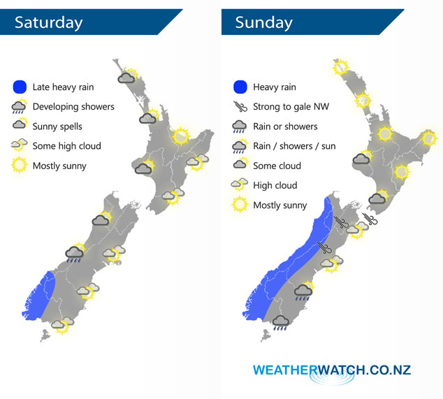
A northwest airflow develops on Saturday, especially for the South Island. Northwesterlies continue on Sunday, a front within this flow slowly pushes northwards during the day moving into the lower South Island in the morning reaching central New Zealand around midnight.
Sunny spells for the western North Island on Saturday, mainly dry in the east with some high cloud possible. The South Islands West Coast sees increasing cloud, the odd light shower moves into Fiordland then overnight expect heavy rain. Mainly sunny in the east with some developing high cloud and warm temperatures getting into the mid twenties for some.
Mostly sunny for a majority of the North Island on Sunday, some cloud in the southwest however. Warm out east with high’s in the mid to late twenties. Heavy rain pushes northwards along the West Coast of the South Island during the day, high cloud out east with strong northwest winds about the upper South Island. Some rain moves into Southland in the morning then Otago during the afternoon with a southwest change.
By Weather Analyst Aaron Wilkinson – WeatherWatch.co.nz
Latest Video

Cold weekend, frosts return with high pressure, then a low late next week
The subantarctic airflow spreads over NZ today/tonight and into Saturday, dropping temperatures nationwide. Snow flurries are possible today to lower…
Related Articles
Cold weekend, frosts return with high pressure, then a low late next week
The subantarctic airflow spreads over NZ today/tonight and into Saturday, dropping temperatures nationwide. Snow flurries are possible today to lower…

Wintry burst of weather: Snow, squally showers then sunshine & frosts
A polar change (another one!) arrives on Friday for the South Island and goes nationwide on Saturday, leaving NZ under…

Antarctic southerly for parts of NZ Fri & Sat
For the first time this year a southerly from off Antarctica is heading towards the South Island, followed by more…

