InfoGraphic: The Big Picture for Saturday / Sunday
21/12/2018 2:00am

> From the WeatherWatch archives
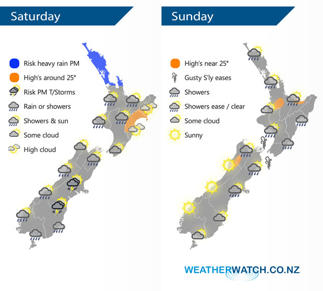
An area of low pressure brings rain to the upper North Island from afternoon on Saturday meanwhile further south over the South Island another area of low pressure brings the chance of unstable conditions in the afternoon for some. Low pressure moves away from the North Island on Sunday and high pressure builds further south.
Rain spreads southwards over the upper North Island during Saturday afternoon, rain may be heavy especially Auckland northwards. A morning shower or two for the lower western North Island then mainly dry. Some rain may spread into Hawkes Bay and Gisborne overnight, dry during the day. A light shower could affect Wairarapa from late morning. A shower or two for the West Coast of the South Island, rain develops in the morning for the lower South Island then easing to showers during the afternoon. Showers about Canterbury in the afternoon may become heavy with thunderstorms and hail then easing in the evening.
Showers clear early morning for the upper North Island on Sunday then sunny areas increase, mostly cloudy for the east coast with the odd shower for much of the day. Mostly sunny for the lower western North Island also after any early showers clear. Gusty southerlies through Cook Strait gradually ease. Showers for the upper South Island gradually clear away, some sun may break through from afternoon, a mix of sun and cloud for most further south however the West Coast gets the best of the lot with sunny skies all day.
By Weather Analyst Aaron Wilkinson – WeatherWatch.co.nz
Latest Video

Frosts, clearer skies coming – severe weather possible this weekend
High pressure lies south of NZ today and that placement encourages a colder south-east wind into the North Island bringing…
Related Articles
Frosts, clearer skies coming – severe weather possible this weekend
High pressure lies south of NZ today and that placement encourages a colder south-east wind into the North Island bringing…

NZ: 8 Day outlook as gales & rain ease, high pressure builds
Damaging wind gusts and heavy rain will continue to affect some parts of the North Island and brushing Marlborough today…

Pockets of hit & miss heavy rain, snow moves northwards
Low pressure continues to slowly move across the upper North Island and for some that will bring the sun out,…

