InfoGraphic: The Big Picture for Saturday / Sunday
2/03/2018 4:00am

> From the WeatherWatch archives
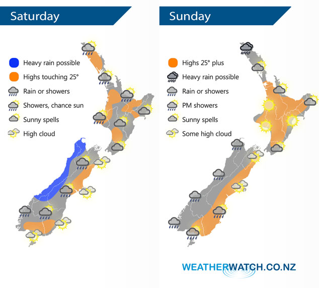
Low pressure sits west of the country on Saturday meanwhile a large high sits out to the east, both systems combine to direct a northeasterly airflow over New Zealand. Sunday sees a slack pressure gradient form over the country bringing fairly settled conditions however there is still some rain activity for the South Island’s West Coast and for Northland.
For the North Island conditions are mainly dry on Saturday however there is the chance of a morning shower for some northeastern regions. Northern parts of Northland sees the odd shower continue for much of the day. For the South Island rain continues in the west with the chance of a heavy fall or two, drier out east although a shower or two may sneak in at times especially inland.
Mainly settled for the North Island on Sunday, northern parts of Northland sees some rain with even the chance of a heavy fall at times. Mainly dry for the South Island’s East Coast, a few showers move into Southland and Otago during the afternoon / evening however. Rain continues at times along the West Coast.
By Weather Analyst Aaron Wilkinson – WeatherWatch.co.nz
Latest Video

Cold weekend, frosts return with high pressure, then a low late next week
The subantarctic airflow spreads over NZ today/tonight and into Saturday, dropping temperatures nationwide. Snow flurries are possible today to lower…
Related Articles
Cold weekend, frosts return with high pressure, then a low late next week
The subantarctic airflow spreads over NZ today/tonight and into Saturday, dropping temperatures nationwide. Snow flurries are possible today to lower…

Wintry burst of weather: Snow, squally showers then sunshine & frosts
A polar change (another one!) arrives on Friday for the South Island and goes nationwide on Saturday, leaving NZ under…

Antarctic southerly for parts of NZ Fri & Sat
For the first time this year a southerly from off Antarctica is heading towards the South Island, followed by more…

