InfoGraphic: The Big Picture for Saturday / Sunday
16/11/2018 7:05pm

> From the WeatherWatch archives
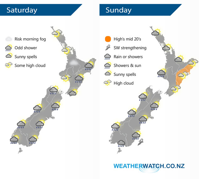
Mostly anticyclonic for the North Island on Saturday bringing mainly settled conditions, a slight area of low pressure and a weak frontal zone bring a few showers or some rain to some South Island regions. A cold southerly blast is looking to push northwards over the South Island on Sunday meanwhile a northwesterly airflow lies over the North Island.
Mostly sunny weather for the North Island on Saturday, some high cloud can be expected. Isolated showers about the ranges of Hawkes Bay / Gisborne from afternoon, some could be heavy with a risk of thunder then easing in the evening. Morning cloud about Kapiti may bring some drizzle, Wellington sees cloudy areas for much of the day. Most parts of the South Island see a few showers, Nelson and Marlborough will likely be the driest spot, also coastal Canterbury after any morning showers clear. North Westland may see a heavy fall or two move in now and then.
A mix of sun and cloud for the upper North Island on Sunday, may be an isolated shower in the afternoon then easing evening. The odd shower about Kapiti and Taranaki spreading and becoming a bit more widespread by evening about the southwestern corner of the North Island, mainly dry in the east with warm temperatures. Early showers ease for the West Coast, some sun then possible however further showers spread northwards during the day with cold southwesterlies. Showers or some rain about Southland then spreading northwards with a cold south to southwest change reaching Canterbury late afternoon or evening, this change could be quite squally about Canterbury with a risk of hail and thunder.
By Weather Analyst Aaron Wilkinson – WeatherWatch.co.nz
Latest Video

Cold weekend, frosts return with high pressure, then a low late next week
The subantarctic airflow spreads over NZ today/tonight and into Saturday, dropping temperatures nationwide. Snow flurries are possible today to lower…
Related Articles
Cold weekend, frosts return with high pressure, then a low late next week
The subantarctic airflow spreads over NZ today/tonight and into Saturday, dropping temperatures nationwide. Snow flurries are possible today to lower…

Wintry burst of weather: Snow, squally showers then sunshine & frosts
A polar change (another one!) arrives on Friday for the South Island and goes nationwide on Saturday, leaving NZ under…

Antarctic southerly for parts of NZ Fri & Sat
For the first time this year a southerly from off Antarctica is heading towards the South Island, followed by more…

