InfoGraphic: The Big Picture for Saturday / Sunday
26/10/2018 1:28am

> From the WeatherWatch archives
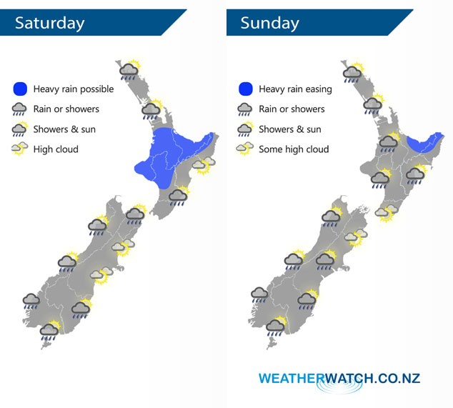
A weakening front moves onto the lower South Island on Saturday meanwhile a low pushes onto the North Island from the west. This low passes out to the east of the North Island on Sunday meanwhile the South Island under a slack pressure gradient may see a dry morning for many then a few showers cropping up in the afternoon.
Thickening cloud for much of the western North Island on Saturday, rain moves in during the afternoon with heavy falls possible about the Waikato through to Manawatu then easing overnight for most. The east coast is mainly dry, some rain moves in mid to late afternoon about Wairarapa then easing overnight. A mostly cloudy day for the West Coast of the South Island, chance of a shower or two mainly in the morning, some rain moves into Fiordland around midday. High cloud for Nelson and Marlborough, chance spot of rain in the afternoon / evening otherwise mainly dry. Elsewhere in the east morning cloud breaks to mostly sunny weather, a few showers affect Southland from afternoon and an isolated shower or two may make their way into Otago late afternoon / evening.
Heavy rain eases about Bay Of Plenty / East Cape during Sunday, expect a mix of sun and showers for most of the North Island otherwise. Isolated showers about Waikato and Bay Of Plenty may become heavy in the afternoon then easing evening. A mainly dry morning for most the South Island, showers about South Westland however. Isolated showers cropping up for most places in the afternoon however Nelson, Marlborough and coastal Canterbury may stay largely dry.
By Weather Analyst Aaron Wilkinson – WeatherWatch.co.nz
Latest Video

Cold weekend, frosts return with high pressure, then a low late next week
The subantarctic airflow spreads over NZ today/tonight and into Saturday, dropping temperatures nationwide. Snow flurries are possible today to lower…
Related Articles
Cold weekend, frosts return with high pressure, then a low late next week
The subantarctic airflow spreads over NZ today/tonight and into Saturday, dropping temperatures nationwide. Snow flurries are possible today to lower…

Wintry burst of weather: Snow, squally showers then sunshine & frosts
A polar change (another one!) arrives on Friday for the South Island and goes nationwide on Saturday, leaving NZ under…

Antarctic southerly for parts of NZ Fri & Sat
For the first time this year a southerly from off Antarctica is heading towards the South Island, followed by more…

