InfoGraphic: The Big Picture for Saturday / Sunday
5/10/2018 6:11pm

> From the WeatherWatch archives
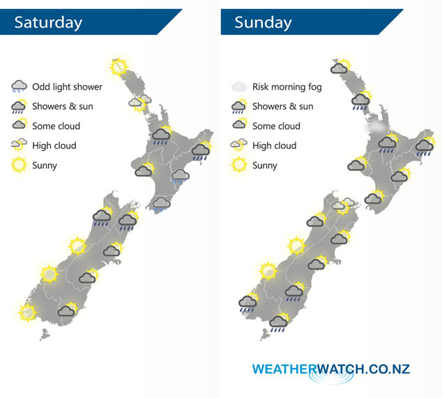
An anticyclone brings mainly settled weather for New Zealand on Saturday, some cloud at times however especially in the morning and for much of the day along the North Island’s East Coast. Still quite anticyclonic on Sunday however a front does push onto the lower South Island and some slight instability leads to afternoon showers for some upper North Island regions.
Mostly sunny for the upper North Island on Saturday, afternoon showers possible about southern Auckland, Waikato and inland Bay Of Plenty. Cloudy for the Wairarapa with the odd light shower, cloud and the risk of a shower spreading northwards along the east coast during the morning. Morning cloud about Wellington breaks to some sun from afternoon. The South Island has plenty of morning cloud in the east then some afternoon sun breaks through, chance of an isolated shower or two about some inland parts of the upper South Island late afternoon / evening. Mostly sunny elsewhere.
Fairly sunny Auckland northwards on Sunday, a fair amount of cloud elsewhere about the upper North Island to start the day especially away from the coast inland. Cloud breaks in the afternoon to some sun however at the same time builds from Northland down then right across to Gisborne bringing the chance of heavy isolated showers late afternoon / evening. The lower North Island has a mix of sun and cloud for much of the day, sunny areas may be longer nearer the coast. The South Island has a mix of sun and cloud for many, a few showers move onto Southland by midday and a few may reach Otago by evening.
By Weather Analyst Aaron Wilkinson – WeatherWatch.co.nz
Latest Video

NZ: 8 Day outlook as gales & rain ease, high pressure builds
Damaging wind gusts and heavy rain will continue to affect some parts of the North Island and brushing Marlborough today…
Related Articles
NZ: 8 Day outlook as gales & rain ease, high pressure builds
Damaging wind gusts and heavy rain will continue to affect some parts of the North Island and brushing Marlborough today…

Pockets of hit & miss heavy rain, snow moves northwards
Low pressure continues to slowly move across the upper North Island and for some that will bring the sun out,…

Slow go for northern low & southern cold
For the next few days low pressure will crawl over the upper North Island, driving in rain as far south…

