InfoGraphic: The Big Picture for Saturday / Sunday
17/08/2018 7:50pm

> From the WeatherWatch archives
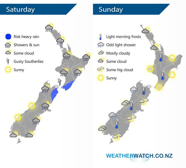
A cold southerly airflow eases from the south over New Zealand on Saturday with a ridge of high pressure pushing over the South Island during the day then the North Island overnight. This ridge weakens over the North Island on Sunday and a northerly airflow then increases.
Showers for most of the western North Island on Saturday, clearing in the evening. Rain about the Wairarapa may be heavy in the morning then easing and pushing northwards during the afternoon, rain clears overnight. Early rain about Marlborough may be heavy then easing and clearing away, shower activity for the rest of the South Island clears in the morning then sunny spells increase from afternoon. Mainly sunny weather on the West Coast and about Southland / Otago, any morning cloud for Southland / Otago clears away.
A mainly sunny day for the North Island on Sunday, there may be some cloud at times Auckland northwards, winds are light. Also a chance of morning frosts especially for inland areas. For the South Island cloud thickens up along the West Coast in the morning, the odd light shower is possible also then some rain develops later in the evening. Dry in the east with mostly sunny weather and some increasing high cloud.
By Weather Analyst Aaron Wilkinson – WeatherWatch.co.nz
Latest Video

NZ: 8 Day outlook as gales & rain ease, high pressure builds
Damaging wind gusts and heavy rain will continue to affect some parts of the North Island and brushing Marlborough today…
Related Articles
NZ: 8 Day outlook as gales & rain ease, high pressure builds
Damaging wind gusts and heavy rain will continue to affect some parts of the North Island and brushing Marlborough today…

Pockets of hit & miss heavy rain, snow moves northwards
Low pressure continues to slowly move across the upper North Island and for some that will bring the sun out,…

Slow go for northern low & southern cold
For the next few days low pressure will crawl over the upper North Island, driving in rain as far south…

