InfoGraphic: The Big Picture for Saturday / Sunday
20/07/2018 3:00am

> From the WeatherWatch archives
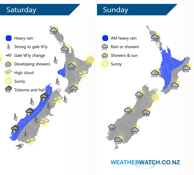
A front pushes northwards over the South Island during Saturday, reaching the western North Island later in the evening. Expect strong northerly winds ahead of this front then changing westerly in behind. This front continues northwards over the North Island during Sunday meanwhile a cold southerly change lines up for the lower South Island.
Heavy rain for the West Coast of the South Island spreads into Taranaki later in the evening on Saturday, thunderstorms and hail are possible also mainly from afternoon for the West Coast. Expect strong northerly winds for many parts of the South Island and lower North Island during the day, changing westerly during the afternoon and evening.
Some heavy rain for the western North Island gradually eases from the south during the day, expect showers otherwise with spots of rain spreading to the east coast. Morning rain for the west of the South Island eases to showers. A fairly dry day for the east coast with good weather, from afternoon cold southerlies move into the lower South Island bringing rain, this moves northwards later in the evening and overnight.
By Weather Analyst Aaron Wilkinson – WeatherWatch.co.nz
Latest Video

Cold weekend, frosts return with high pressure, then a low late next week
The subantarctic airflow spreads over NZ today/tonight and into Saturday, dropping temperatures nationwide. Snow flurries are possible today to lower…
Related Articles
Cold weekend, frosts return with high pressure, then a low late next week
The subantarctic airflow spreads over NZ today/tonight and into Saturday, dropping temperatures nationwide. Snow flurries are possible today to lower…

Wintry burst of weather: Snow, squally showers then sunshine & frosts
A polar change (another one!) arrives on Friday for the South Island and goes nationwide on Saturday, leaving NZ under…

Antarctic southerly for parts of NZ Fri & Sat
For the first time this year a southerly from off Antarctica is heading towards the South Island, followed by more…

