InfoGraphic: The Big Picture for Saturday / Sunday
25/05/2018 9:28pm

> From the WeatherWatch archives
A cold southwest airflow lies over New Zealand on Saturday, a cold front within this flow hits the lower South Island around midday then pushes northwards to reach the lower North Island overnight. Cold southwesterlies continue on Sunday. Tuesday next week is the first sign of settled sunny weather for the whole South Island and western North Island however it will likely be very frosty in the morning.
Morning showers clear the upper North Island on Saturday then mainly sunny, a similar picture for south of Taranaki in the west although cloud builds in the evening with the odd late shower possible. A few showers for the coastal fringes along the east coast gradually easing and clearing during the day, cold southwesterly winds. Just inland in the east morning cloud breaks to sunny areas which increase. Overnight a gusty southerly change moves into Wellington bringing showers.
Mainly sunny for the upper South Island on Saturday, just some high cloud at times. Rain pushes into Fiordland in the morning then moves northwards along the West Coast during the day, there may be a few heavy falls although not looking too bad. Rain pushes into Southland around midday then Otago during the afternoon with a cold southwest change, easing back to showers after a period of time, some snow may lower to 300m during the evening. Later in the evening or overnight southwesterlies freshen about Canterbury bringing a few showers, they are fairly fleeting however.
Showers for most regions around New Zealand on Sunday. The West Coast of the South Island is mainly sunny, just morning showers for Buller then clearing. Winds are brisk to strong from the south or southwest about many coastal parts of the country during the day.
Snow flurries gradually lower in the east to low levels (200 to 100m) about Southland and Otago by evening, 300m in the evening for Canterbury and to 400m overnight about the Central North Island. This snow isn’t overly heavy however the low’ish levels will be of some concern, parts of North Otago and South Canterbury may only see a brief skiff due to the southwesterly nature of the airflow.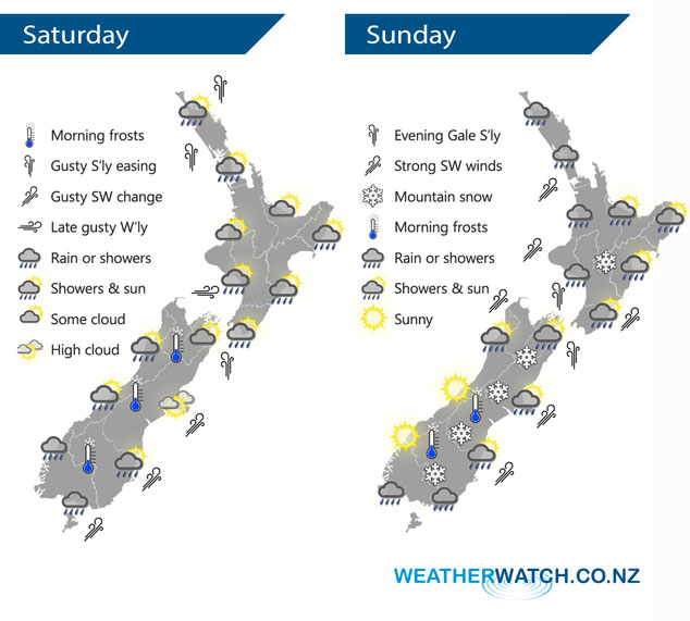
By Weather Analyst Aaron Wilkinson – WeatherWatch.co.nz
Comments
Latest Video

NZ: 8 Day outlook as gales & rain ease, high pressure builds
Damaging wind gusts and heavy rain will continue to affect some parts of the North Island and brushing Marlborough today…
Related Articles
NZ: 8 Day outlook as gales & rain ease, high pressure builds
Damaging wind gusts and heavy rain will continue to affect some parts of the North Island and brushing Marlborough today…

Pockets of hit & miss heavy rain, snow moves northwards
Low pressure continues to slowly move across the upper North Island and for some that will bring the sun out,…

Slow go for northern low & southern cold
For the next few days low pressure will crawl over the upper North Island, driving in rain as far south…


LM on 25/05/2018 10:57pm
Got to love how your ‘snow’ level for the far south today is twice as low as MS are forecasting. Seems to be stock standard wording in your winter forecasts for down here!