> From the WeatherWatch archives
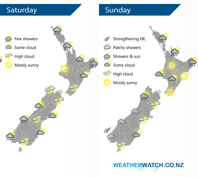
A large anticyclone centred to the southeast of the South Island spreads a ridge over New Zealand on Saturday. This ridge starts to weaken on Sunday with a northerly airflow starting to increase over the South Island.
Cloudy areas and the odd shower for the eastern North Island, Coromandel, northern Auckland and Northland on Saturday. Mostly sunny in the west Waikato southwards after any morning cloud breaks away. Morning cloud for the eastern South Island breaks to sunny areas, sunny spells for the West Coast and the odd light shower about South Westland.
A shower or two for northeastern parts of the North Island on Sunday although dry areas become longer from afternoon. Mainly dry elsewhere for the lower North Island. A dry day for the eastern South Island meanwhile the odd light shower starts to increase in the west.
By Weather Analyst Aaron Wilkinson – WeatherWatch.co.nz
Latest Video

Cold weekend, frosts return with high pressure, then a low late next week
The subantarctic airflow spreads over NZ today/tonight and into Saturday, dropping temperatures nationwide. Snow flurries are possible today to lower…
Related Articles
Cold weekend, frosts return with high pressure, then a low late next week
The subantarctic airflow spreads over NZ today/tonight and into Saturday, dropping temperatures nationwide. Snow flurries are possible today to lower…

Wintry burst of weather: Snow, squally showers then sunshine & frosts
A polar change (another one!) arrives on Friday for the South Island and goes nationwide on Saturday, leaving NZ under…

Antarctic southerly for parts of NZ Fri & Sat
For the first time this year a southerly from off Antarctica is heading towards the South Island, followed by more…

