InfoGraphic: The Big Picture for Monday / Tuesday
29/03/2020 5:25pm
> From the WeatherWatch archives
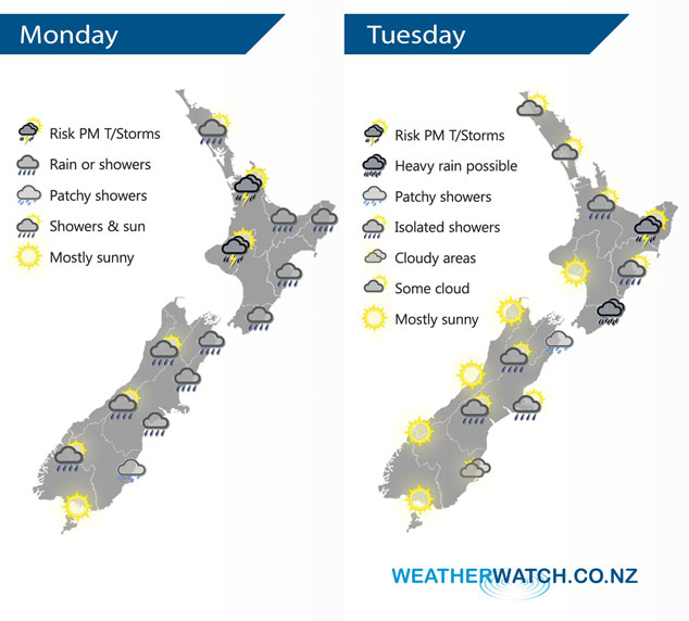
A large anticyclone centred to the southeast of New Zealand pushes an easterly quarter airflow over the country today. A ridge of high pressure lies over the South Island on Tuesday meanwhile an occluded front to the east curls into a weak area of low pressure over the North Island.
Showers or rain for most east / northeastern parts of the North Island today although it will be dry this morning for most of Northland (especially in the west) down through to Taranaki. Showers push in this afternoon for southern parts of Northland down through to northern Taranaki with heavy falls and possible thunderstorms. The east coast (Gisborne to Wairarapa) may see isolated heavy falls. Generally speaking we see rain or showers for the eastern South Island today, drier in the west although isolated showers may develop about the ranges late afternoon / evening.
Looking drier for the North Island on Tuesday, the odd isolated shower may creep into Waikato / Bay Of Plenty late afternoon / evening. Rain about Wairarapa may be heavy in the morning then easing, mainly dry for Hawkes Bay / Gsiborne however during the afternoon isolated showers develop about the ranges, some may become heavy with thunderstorms. Cloud and the odd shower / drizzle patch for eastern parts of the South Island on Tuesday, sunnier conditions out west.
By Weather Analyst Aaron Wilkinson – WeatherWatch.co.nz
Latest Video

Cold weekend, frosts return with high pressure, then a low late next week
The subantarctic airflow spreads over NZ today/tonight and into Saturday, dropping temperatures nationwide. Snow flurries are possible today to lower…
Related Articles
Cold weekend, frosts return with high pressure, then a low late next week
The subantarctic airflow spreads over NZ today/tonight and into Saturday, dropping temperatures nationwide. Snow flurries are possible today to lower…

Wintry burst of weather: Snow, squally showers then sunshine & frosts
A polar change (another one!) arrives on Friday for the South Island and goes nationwide on Saturday, leaving NZ under…

Antarctic southerly for parts of NZ Fri & Sat
For the first time this year a southerly from off Antarctica is heading towards the South Island, followed by more…

