InfoGraphic: The Big Picture for Monday / Tuesday
22/03/2020 6:00pm
> From the WeatherWatch archives
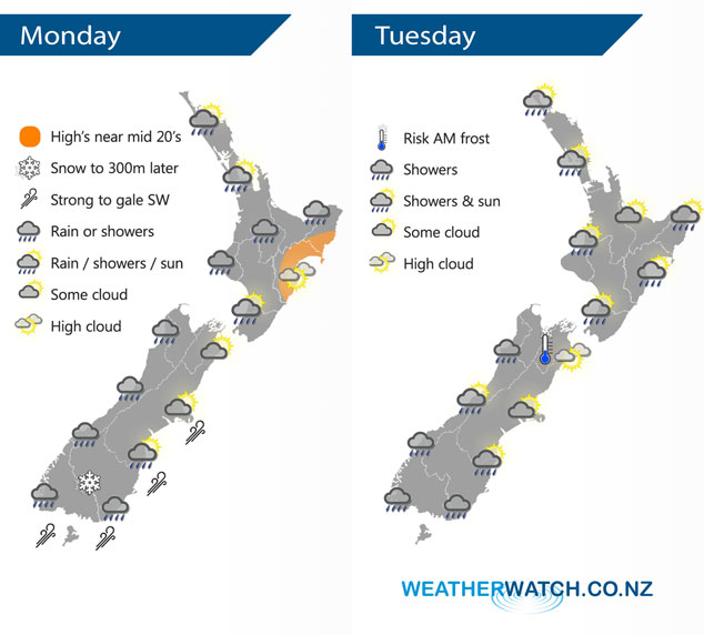
A series of fronts move over New Zealand today bringing mainly wet weather in the west and dry weather out east. A fairly cold southwest change moves into Southland this afternoon bringing rain reaching Canterbury in the evening however by then it will only bring a few showers. Cool southwesterlies continue on Tuesday.
Showers for the western / upper North Island today, rain moves in from the west this evening. Mainly dry in the east with some high cloud. Showers for the West Coast of the South Island, rain moves into Fiordland this morning then moves northwards. Rain moves into Southland by midday then Otago this afternoon, a few showers reach Canterbury this evening with a strong SW change. Snow lowers about the far south to 300m this evening.
Occasional showers for most coastal parts of the North Island on Tuesday, the Bay Of Plenty stays mainly dry. Expect showers for the western and south of the South Island, mainly dry in the east. There may be a light morning frost for inland Marlborough.
By Weather Analyst Aaron Wilkinson – WeatherWatch.co.nz
Latest Video

Slow go for northern low & southern cold
For the next few days low pressure will crawl over the upper North Island, driving in rain as far south…
Related Articles
Slow go for northern low & southern cold
For the next few days low pressure will crawl over the upper North Island, driving in rain as far south…

Slow moving low to track over northern NZ
A low pressure zone will slowly cross the North Island over the coming days, bringing hit and miss pockets of…

NI low pressure, SI polar change
Low pressure will move over the upper North Island this week, bringing hit and miss pockets of heavier rain into…

