InfoGraphic: The Big Picture for Monday / Tuesday
10/11/2019 6:00pm

> From the WeatherWatch archives
A low pressure system moves out of the Tasman Sea and across the upper North Island today meanwhile expect a moderate southwesterly airflow for the South Island. A southwesterly airflow lies over New Zealand on Tuesday, perhaps becoming a little unstable for the eastern North Island during the afternoon.
An area of rain develops about Northland this morning, moving across to Coromandel in the afternoon and finally East Cape this evening bringing a risk of heavy falls / thunderstorms. The odd shower beforehand, southwesterlies gradually develop. Morning rain in the southwest eases to showers then clearing in the afternoon, rain for Wellington and Wairarapa eases to showers in the afternoon then clearing evening. Hawkes Bay and Gisborne are relatively dry, heavy showers and possible thunderstorms from late afternoon northern Hawkes Bay northwards. Most regions see some wet weather in the South Island, easing in the afternoon along the east coast. Thunderstorms may crop up in the afternoon for western parts of the Island.
A period of morning rain or showers for the upper North Island on Tuesday then clearing early afternoon. The odd shower becomes heavy along the east coast in the afternoon then clearing later in the evening. The South Island is relatively dry, isolated showers may develop in the afternoon for Marlborough and the odd shower moves into the West Coast during the day north of the Glaciers. Evening showers move in to Fiordland turning to rain there overnight.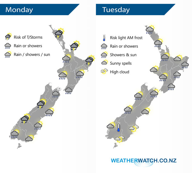
By Weather Analyst Aaron Wilkinson – WeatherWatch.co.nz
Latest Video

Cold weekend, frosts return with high pressure, then a low late next week
The subantarctic airflow spreads over NZ today/tonight and into Saturday, dropping temperatures nationwide. Snow flurries are possible today to lower…
Related Articles
Cold weekend, frosts return with high pressure, then a low late next week
The subantarctic airflow spreads over NZ today/tonight and into Saturday, dropping temperatures nationwide. Snow flurries are possible today to lower…

Wintry burst of weather: Snow, squally showers then sunshine & frosts
A polar change (another one!) arrives on Friday for the South Island and goes nationwide on Saturday, leaving NZ under…

Antarctic southerly for parts of NZ Fri & Sat
For the first time this year a southerly from off Antarctica is heading towards the South Island, followed by more…

