InfoGraphic: The Big Picture for Monday / Tuesday
18/03/2018 6:00pm

> From the WeatherWatch archives
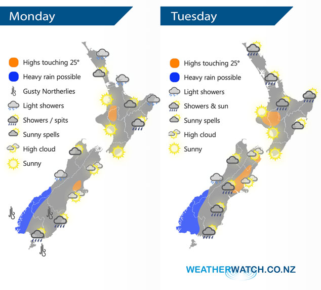
Today we have a ridge of high pressure covering most of New Zealand, an easterly airflow moving around this ridge pushes over the North Island during the day while a northerly airflow lies over the South Island. And finally a front affects the lower South Island. A similar pattern continues on Tuesday.
A shower or two affects some eastern and northeastern parts of the North Island today, mainly exposed places although most of Northland should see a shower or two. Sunnier conditions out west. For the South Island it’s mainly dry in the east although a few spots of rain may work their way into Southland and Otago, perhaps even South Canterbury this evening. Rain for the West Coast south of Greymouth with a few heavy falls.
Showers are looking a bit more likely for the upper North Island on Tuesday especially from afternoon, there is even the low risk of an isolated heavy fall or two. Calmer and sunnier conditions for the western and lower North Island. Rain once again for South Westland with heavy falls possible, most likely about Fiordland. Drier in the east with some high cloud although some rain moves into Southland during the afternoon and perhaps reaching parts of Otago in the evening.
By Weather Analyst Aaron Wilkinson – WeatherWatch.co.nz
Latest Video

Cold weekend, frosts return with high pressure, then a low late next week
The subantarctic airflow spreads over NZ today/tonight and into Saturday, dropping temperatures nationwide. Snow flurries are possible today to lower…
Related Articles
Cold weekend, frosts return with high pressure, then a low late next week
The subantarctic airflow spreads over NZ today/tonight and into Saturday, dropping temperatures nationwide. Snow flurries are possible today to lower…

Wintry burst of weather: Snow, squally showers then sunshine & frosts
A polar change (another one!) arrives on Friday for the South Island and goes nationwide on Saturday, leaving NZ under…

Antarctic southerly for parts of NZ Fri & Sat
For the first time this year a southerly from off Antarctica is heading towards the South Island, followed by more…

