InfoGraphic: The Big Picture for Monday / Tuesday
30/06/2019 7:00pm

> From the WeatherWatch archives
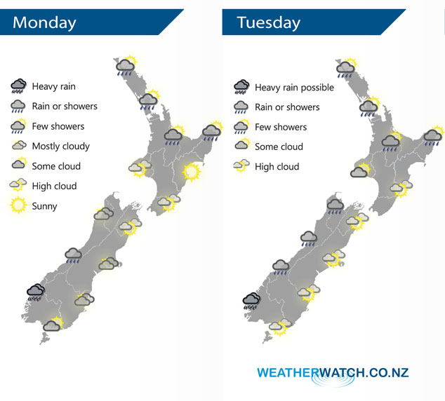
A large anticyclone centred to the east of New Zealand today and on Tuesday drags a northerly quarter airflow over the country.
Cloudy areas for the northeastern North Island today, expect a few showers at times with northeasterly winds. Drier to the south with some high cloud. Mostly cloudy for the South Islands West Coast, rain about Fiordland may be heavy. Thick high cloud for the eastern South Island, Southland starts to see brighter conditions from afternoon.
A similar pattern again on Tuesday for the North Island, the West Coast of the South Island has rain or showers, possibly heavy about Fiordland. The Nelson region sees a few showers creep in by midday, sunny areas and some high cloud out east.
By Weather Analyst Aaron Wilkinson – WeatherWatch.co.nz
Latest Video

Cold weekend, frosts return with high pressure, then a low late next week
The subantarctic airflow spreads over NZ today/tonight and into Saturday, dropping temperatures nationwide. Snow flurries are possible today to lower…
Related Articles
Cold weekend, frosts return with high pressure, then a low late next week
The subantarctic airflow spreads over NZ today/tonight and into Saturday, dropping temperatures nationwide. Snow flurries are possible today to lower…

Wintry burst of weather: Snow, squally showers then sunshine & frosts
A polar change (another one!) arrives on Friday for the South Island and goes nationwide on Saturday, leaving NZ under…

Antarctic southerly for parts of NZ Fri & Sat
For the first time this year a southerly from off Antarctica is heading towards the South Island, followed by more…

