InfoGraphic: The Big Picture for Monday / Tuesday
9/06/2019 7:00pm

> From the WeatherWatch archives
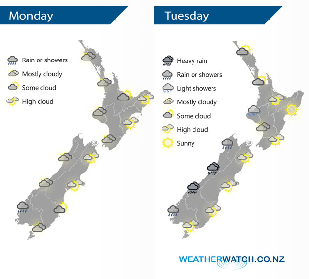
A ridge of high pressure brings mainly settled conditions to New Zealand today, plenty of cloud about though especially in the west. A northwesterly airflow picks up on Tuesday with a front moving onto the South Island from the west afternoon / evening.
Quite cloudy for western New Zealand today, sunnier conditions with high cloud out east. Western regions have the risk of a shower at times, the greatest risk bring about Fiordland.
A mainly dry Tuesday for most of the North Island however northern Taranaki and Kapiti may see a light shower or two. The West Coast of the South Island sees rain, becoming heavy from afternoon then easing overnight. Another mainly dry day in the east with some high cloud, Southland and Otago may see a spot of rain at times from afternoon otherwise mainly dry.
By Weather Analyst Aaron Wilkinson – WeatherWatch.co.nz
Latest Video

Cold weekend, frosts return with high pressure, then a low late next week
The subantarctic airflow spreads over NZ today/tonight and into Saturday, dropping temperatures nationwide. Snow flurries are possible today to lower…
Related Articles
Cold weekend, frosts return with high pressure, then a low late next week
The subantarctic airflow spreads over NZ today/tonight and into Saturday, dropping temperatures nationwide. Snow flurries are possible today to lower…

Wintry burst of weather: Snow, squally showers then sunshine & frosts
A polar change (another one!) arrives on Friday for the South Island and goes nationwide on Saturday, leaving NZ under…

Antarctic southerly for parts of NZ Fri & Sat
For the first time this year a southerly from off Antarctica is heading towards the South Island, followed by more…

