InfoGraphic: The Big Picture for Monday / Tuesday
4/03/2018 6:00pm

> From the WeatherWatch archives
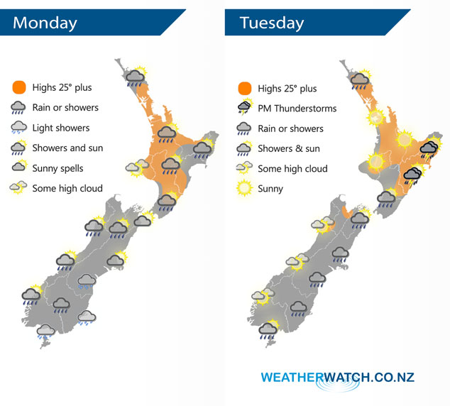
A slack pressure gradient lies over New Zealand today, this can create light shifty winds and areas of convergence which may lead to a downpour or two. A similar situation occurs for the North Island on Tuesday with a higher chance of downpours, especially in the east with thunderstorms. Rain for the east of the South Island with cooler southerlies, drier in the west.
Mainly dry for much of the North Island however a few isolated showers may develop this afternoon, mainly about Northland and inland hills / ranges along the east coast. The South Island sees a few showers about also, clearing away from most coastal areas in the afternoon and becoming more restricted to inland hills and ranges.
Tuesday sees rain for the east of the South Island as cool southerlies push northwards, drier in the west although just inland about the main divide some rain will push over from the east. Another mainly dry morning for the North Island then showers develop in the afternoon especially about Northland, Bay Of Plenty and along the east coast. Showers in the east and about the Bay Of Plenty becoming heavy with a risk of thunderstorms which ease later in the evening.
By Weather Analyst Aaron Wilkinson – WeatherWatch.co.nz
Latest Video

Cold weekend, frosts return with high pressure, then a low late next week
The subantarctic airflow spreads over NZ today/tonight and into Saturday, dropping temperatures nationwide. Snow flurries are possible today to lower…
Related Articles
Cold weekend, frosts return with high pressure, then a low late next week
The subantarctic airflow spreads over NZ today/tonight and into Saturday, dropping temperatures nationwide. Snow flurries are possible today to lower…

Wintry burst of weather: Snow, squally showers then sunshine & frosts
A polar change (another one!) arrives on Friday for the South Island and goes nationwide on Saturday, leaving NZ under…

Antarctic southerly for parts of NZ Fri & Sat
For the first time this year a southerly from off Antarctica is heading towards the South Island, followed by more…

