InfoGraphic: The Big Picture for Monday / Tuesday
23/09/2018 7:00pm

> From the WeatherWatch archives
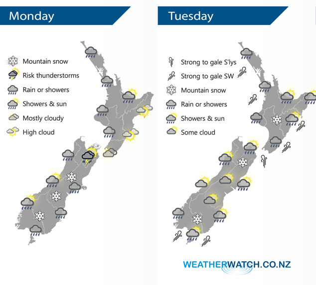
A low pressure system east of New Zealand today brings a cold southerly airflow for the South Island, milder westerlies further north. Strong cold southwesterlies over the South Island spread over the North Island on Tuesday.
Showers for the western North Island today, more persistent from afternoon then a few heavy falls possible this evening. Drier in the east with spots of rain possible this evening. Rain or showers spreading to most parts of the South Island by this afternoon, some may be heavy with thunderstorms and hail for Nelson / Marlborough this afternoon. Snow lowering to low levels (200 to 100m) about the far south of the South Island this evening, 600m overnight for Marlborough.
Rain or showers for much of the North Island on Tuesday, snow to 500m about the Central North Island. Rain or showers clears the upper South Island in the morning then sun breaks through. Dry for much of the lower South Island however showers push into Fiordland, Southland and parts of Otago by midday with snow flurries to 400m.
By Weather Analyst Aaron Wilkinson – WeatherWatch.co.nz
Latest Video

Cold weekend, frosts return with high pressure, then a low late next week
The subantarctic airflow spreads over NZ today/tonight and into Saturday, dropping temperatures nationwide. Snow flurries are possible today to lower…
Related Articles
Cold weekend, frosts return with high pressure, then a low late next week
The subantarctic airflow spreads over NZ today/tonight and into Saturday, dropping temperatures nationwide. Snow flurries are possible today to lower…

Wintry burst of weather: Snow, squally showers then sunshine & frosts
A polar change (another one!) arrives on Friday for the South Island and goes nationwide on Saturday, leaving NZ under…

Antarctic southerly for parts of NZ Fri & Sat
For the first time this year a southerly from off Antarctica is heading towards the South Island, followed by more…

