InfoGraphic: The Big Picture for Monday / Tuesday
19/08/2018 7:00pm

> From the WeatherWatch archives
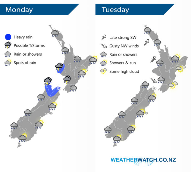
A large low moves onto the lower South Island during today. A northwesterly airflow around the top of this low brings wet weather to much of western New Zealand and drier weather out east, some rain may spill eastwards at times however with the passing of a front. Northwesterlies gradually turn to the southwest on Tuesday.
Rain or showers for the western North Island today, a period of heavy rain possible with thunderstorms especially Taranaki down through to Kapiti. Mostly dry in the east although a few spots may spread from the west at times, mainly later in the day. Rain for the West Coast of the South Island may be heavy at times, especially in the north about Buller / Tasman, also Nelson and Marlborough with a chance of thunderstorms. Drier conditions along the east coast of the South Island although there may be a few spots of rain at times.
Rain or showers for much of western New Zealand on Tuesday, drier in the east although there may be a few showers for a time about the South Island’s east coast.
By Weather Analyst Aaron Wilkinson – WeatherWatch.co.nz
Latest Video

Cold weekend, frosts return with high pressure, then a low late next week
The subantarctic airflow spreads over NZ today/tonight and into Saturday, dropping temperatures nationwide. Snow flurries are possible today to lower…
Related Articles
Cold weekend, frosts return with high pressure, then a low late next week
The subantarctic airflow spreads over NZ today/tonight and into Saturday, dropping temperatures nationwide. Snow flurries are possible today to lower…

Wintry burst of weather: Snow, squally showers then sunshine & frosts
A polar change (another one!) arrives on Friday for the South Island and goes nationwide on Saturday, leaving NZ under…

Antarctic southerly for parts of NZ Fri & Sat
For the first time this year a southerly from off Antarctica is heading towards the South Island, followed by more…

