InfoGraphic: The Big Picture for Monday / Tuesday
29/07/2018 7:00pm

> From the WeatherWatch archives
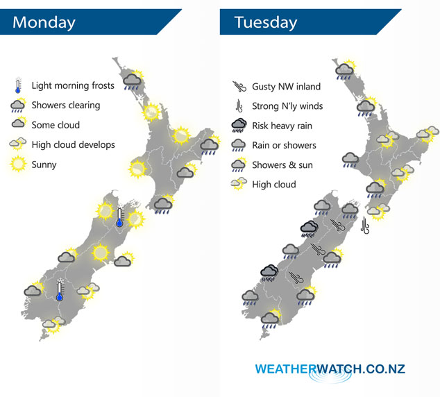
A ridge of high pressure brings in some settled weather today however it doesn’t last very long as a front lines up in the Tasman Sea, moving onto the South Island overnight. This front continues to move northwards during Tuesday although it does slow down a little.
Any showers about the North Island this morning clear away then becoming sunny, southwesterly winds ease. A settled picture for the South Island with mostly sunny weather for most, some high cloud will start to increase about the lower South Island from afternoon and rain moves into South Westland later this evening.
Dry for the western North Island on Tuesday at first with developing high cloud, late afternoon or evening showers move in from the west. Sunny in the east with some high cloud. Rain for the West Coast of the South Island may be heavy, a few spots of rain out east mainly early in the morning then some sun breaks through.
By Weather Analyst Aaron Wilkinson – WeatherWatch.co.nz
Latest Video

Cold weekend, frosts return with high pressure, then a low late next week
The subantarctic airflow spreads over NZ today/tonight and into Saturday, dropping temperatures nationwide. Snow flurries are possible today to lower…
Related Articles
Cold weekend, frosts return with high pressure, then a low late next week
The subantarctic airflow spreads over NZ today/tonight and into Saturday, dropping temperatures nationwide. Snow flurries are possible today to lower…

Wintry burst of weather: Snow, squally showers then sunshine & frosts
A polar change (another one!) arrives on Friday for the South Island and goes nationwide on Saturday, leaving NZ under…

Antarctic southerly for parts of NZ Fri & Sat
For the first time this year a southerly from off Antarctica is heading towards the South Island, followed by more…

