InfoGraphic: The Big Picture for Monday / Tuesday
11/02/2018 6:00pm

> From the WeatherWatch archives
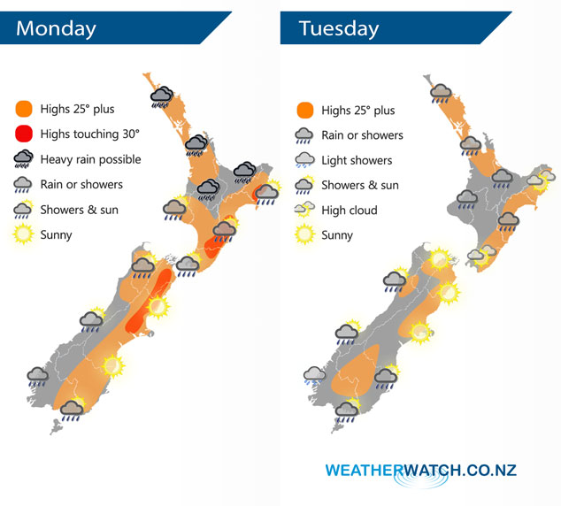
A front lingers over the North Island today and on Tuesday in a very humid northerly quarter airflow. Meanwhile the South Island has generally more settled weather with dry sunny conditions in the east and the odd drizzle patch out west. A southerly flick does bring a few showers to the lower South Island late afternoon / evening however.
Any morning heavy rain for the upper North Island eases then becoming quite patchy, later this afternoon or evening areas of rain reintensify. Conditions are quite warm and very humid. For the South Island it’s a return to summer with sunny conditions in the east and warm temperatures, some morning drizzle in the west clears then sunny spells develop on the West Coast however some rain moves into Fiordland this afternoon. Southland may catch a shower late afternoon / evening.
Tuesday sees showers for many North Island regions, still the chance of a heavy fall or two otherwise conditions may be quite patchy with long dry spells. Sunny for the east of the South Island, a few showers move into Southland and Otago during the afternoon and evening as a southwest flick moves through. Morning drizzle or showers clear the West Coast then sunny spells increase.
By Weather Analyst Aaron Wilkinson – WeatherWatch.co.nz
Latest Video

NZ 7 day forecast: Showers, temp changes and heavy West Coast rain
NZ has a fairly messy forecast over the next 7 days, but the main feature will be heavy rain on…
Related Articles
NZ 7 day forecast: Showers, temp changes and heavy West Coast rain
NZ has a fairly messy forecast over the next 7 days, but the main feature will be heavy rain on…

Cold fronts continue, wind & rain for some Fri/Sat
Wet weather is moving over the North Island today, while the South Island has drier skies – ahead of another…

Cold fronts vs high pressure
A cold front is moving up NZ today and into Tuesday, but will fall apart as it heads north and…

