InfoGraphic: The Big Picture for Monday / Tuesday
27/05/2018 7:00pm

> From the WeatherWatch archives
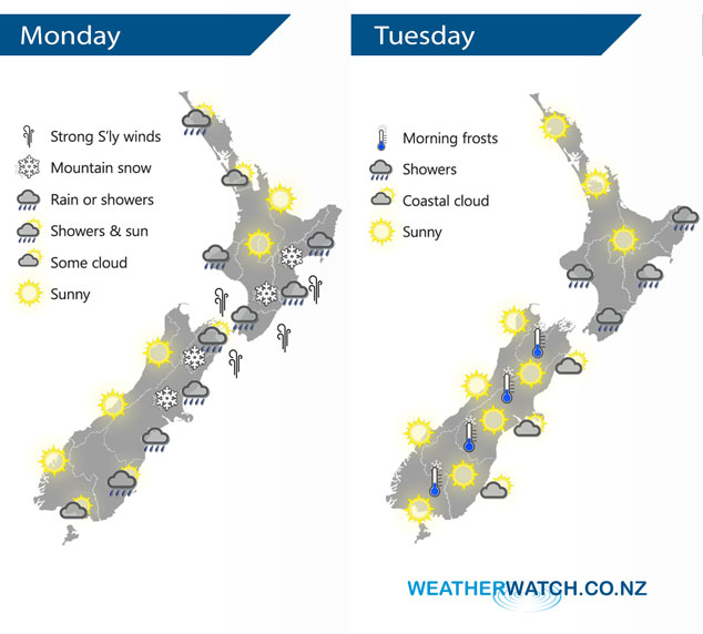
A gusty cold southerly airflow lies over New Zealand today, easing from the south as a ridge of high pressure starts to build over the lower South Island. An anticyclone lies over the South Island on Tuesday while a southerly airflow lies over the North Island.
Cold southerlies for most of New Zealand today, showers in the east although drying out this afternoon for Southland and Otago. Some snow falling to 300m in Canterbury, 400 to 500m Marlborough through to Hawkes Bay. Southerly winds strong through Cook Strait with gales at times.
Mainly sunny weather in the west, morning showers for Northland clear away.
Looking brighter on Tuesday however it will be a frosty start especially for the inner South Island where heavy frosts are possible. Just some coastal cloud possible along the South Island’s east coast. For the North Island a few showers continue in the south, east and west up through to Taranaki. Mainly sunny elsewhere.
By Weather Analyst Aaron Wilkinson – WeatherWatch.co.nz
Comments
Latest Video

Cold weekend, frosts return with high pressure, then a low late next week
The subantarctic airflow spreads over NZ today/tonight and into Saturday, dropping temperatures nationwide. Snow flurries are possible today to lower…
Related Articles
Cold weekend, frosts return with high pressure, then a low late next week
The subantarctic airflow spreads over NZ today/tonight and into Saturday, dropping temperatures nationwide. Snow flurries are possible today to lower…

Wintry burst of weather: Snow, squally showers then sunshine & frosts
A polar change (another one!) arrives on Friday for the South Island and goes nationwide on Saturday, leaving NZ under…

Antarctic southerly for parts of NZ Fri & Sat
For the first time this year a southerly from off Antarctica is heading towards the South Island, followed by more…


Guest on 27/05/2018 8:34pm
Wow!!
It is so good to finally have a REAL Southerly in Wellington.
You know, the one that comes right off the Cook Straight and not one of those girlie Sou’Westerlies that never do much here due to the sheltering of the Southern Alps.
More please, much more!!