InfoGraphic: The Big Picture for Friday / Saturday
12/12/2019 7:11pm

> From the WeatherWatch archives
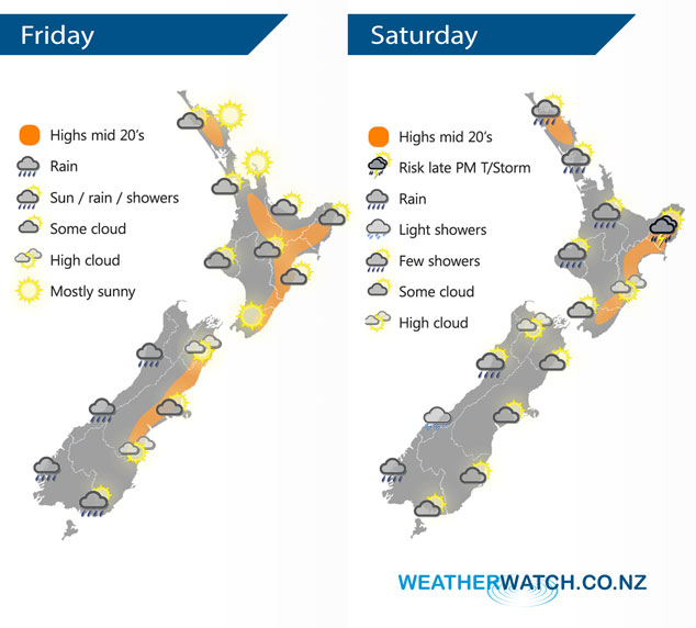
A westerly airflow lies over the North Island today meanwhile a front pushes northwards over the South Island. This front weakens and moves over the North Island on Saturday.
Areas of morning cloud break to mostly sunny weather for much of the North Island today. The odd shower moves into Taranaki and Kapiti in the evening then spreading into other southwestern parts of the North Island overnight. Rain pushes northwards along the West Coast of the South Island during the day, easing evening. Showers move into Southland around midday then Otago late afternoon or evening, a chance as these showers push northwards they may be heavy with the low risk of a thunderstorm. Canterbury has morning cloud break then expect high cloud.
A period of showers for the upper North Island in the morning, the Bay Of Plenty may see showers move through more in the afternoon. A chance as showers move across East Cape in the afternoon they could turn thundery. Mainly dry for the lower North Island. Mostly cloudy for the West Coast of the South Island, some rain for Fiordland and the odd shower further north. Morning cloud in the east breaks to sunny areas and some high cloud.
By Weather Analyst Aaron Wilkinson – WeatherWatch.co.nz
Latest Video

Cold weekend, frosts return with high pressure, then a low late next week
The subantarctic airflow spreads over NZ today/tonight and into Saturday, dropping temperatures nationwide. Snow flurries are possible today to lower…
Related Articles
Cold weekend, frosts return with high pressure, then a low late next week
The subantarctic airflow spreads over NZ today/tonight and into Saturday, dropping temperatures nationwide. Snow flurries are possible today to lower…

Wintry burst of weather: Snow, squally showers then sunshine & frosts
A polar change (another one!) arrives on Friday for the South Island and goes nationwide on Saturday, leaving NZ under…

Antarctic southerly for parts of NZ Fri & Sat
For the first time this year a southerly from off Antarctica is heading towards the South Island, followed by more…

