InfoGraphic: The Big Picture for Friday / Saturday
5/04/2018 7:52pm

> From the WeatherWatch archives
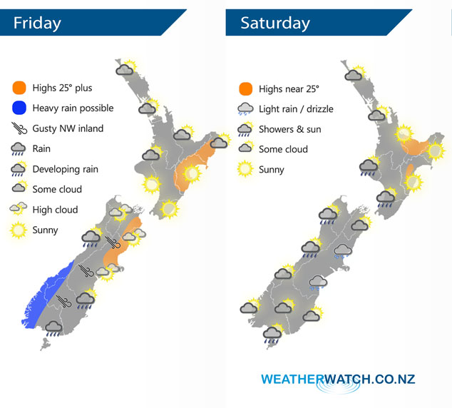
A front pushes onto the lower South Island this morning then weakens as it moves northwards. A ridge lies over the North Island extending out from an anticyclone in the Tasman Sea. Friday’s front continues to move northwards on Saturday but in a much more weakened state, only bringing a few patchy showers as it moves along.
Some cloud for the upper North Island today although expect areas of sun especially this afternoon, a chance of fog this morning for the Waikato. Mostly sunny elsewhere for the North Island.
About the South Island expect mostly cloudy skies in the west, rain about South Westland is heavy at times then clearing later this evening or overnight. In the east conditions are mainly dry and warm with some high cloud ahead of a southwest change, rain pushes into Southland in the morning, Otago early afternoon then southern Canterbury in the evening. Northwesterly winds ahead of this change are gusty about inland areas.
A few showers move onto the lower North Island in the afternoon on Saturday with a south to southwest change, drier further north although there may be some cloud at times for Northland and Auckland in a southwest airflow. For the South Island, showers in the northwest clear in the afternoon then sunny spells increase. Morning cloud about South Westland then mostly sunny. Cloudier skies in the east especially about Canterbury with light showers or drizzle.
By Weather Analyst Aaron Wilkinson – WeatherWatch.co.nz
Latest Video

Pockets of hit & miss heavy rain, snow moves northwards
Low pressure continues to slowly move across the upper North Island and for some that will bring the sun out,…
Related Articles
Pockets of hit & miss heavy rain, snow moves northwards
Low pressure continues to slowly move across the upper North Island and for some that will bring the sun out,…

Slow go for northern low & southern cold
For the next few days low pressure will crawl over the upper North Island, driving in rain as far south…

Slow moving low to track over northern NZ
A low pressure zone will slowly cross the North Island over the coming days, bringing hit and miss pockets of…

