InfoGraphic: The Big Picture for Friday / Saturday
24/10/2019 6:53pm

> From the WeatherWatch archives
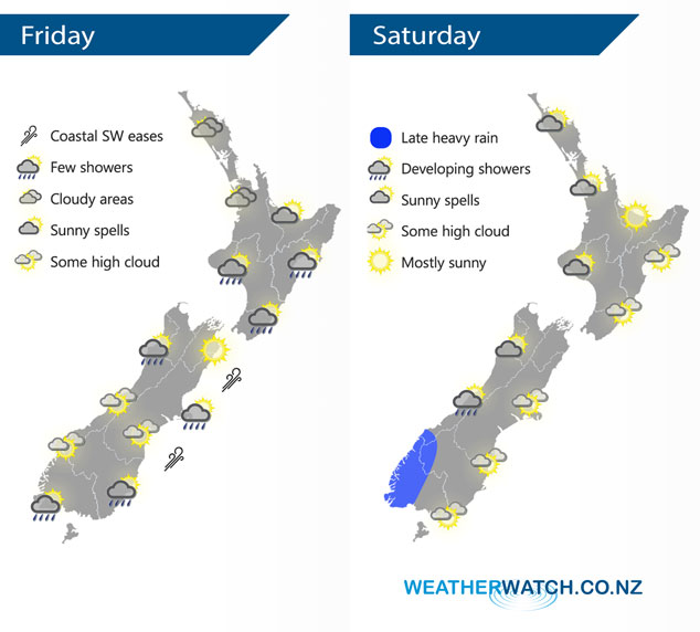
A moderate southwesterly airflow lies over the country today, perhaps strong this morning offshore along the east coast of the South Island then easing. A northwest airflow develops on Saturday, especially for the South Island.
Mostly cloudy for the western and upper North Island today, there may be a shower or two about also especially Taranaki through to Kapiti. The Bay Of Plenty stays mainly dry with more frequent sunny spells. Showers about Wairarapa spread further north along the east coast during the afternoon. Cloudy areas and the odd shower Hokitika northwards for the West Coast, sunnier conditions further south although some high cloud develops. Mostly sunny with developing high cloud in the east, a few showers out on Banks Peninsula don’t clear till evening. Morning showers for Southland and Otago then drying out although expect some high cloud to move in.
Sunny spells for the western North Island on Saturday, mainly dry in the east with some high cloud possible. The South Islands West Coast sees increasing cloud, the odd light shower moves into Fiordland then overnight expect heavy rain. Mainly sunny in the east with some developing high cloud and warm temperatures getting into the mid twenties for some.
By Weather Analyst Aaron Wilkinson – WeatherWatch.co.nz
Latest Video

Cold weekend, frosts return with high pressure, then a low late next week
The subantarctic airflow spreads over NZ today/tonight and into Saturday, dropping temperatures nationwide. Snow flurries are possible today to lower…
Related Articles
Cold weekend, frosts return with high pressure, then a low late next week
The subantarctic airflow spreads over NZ today/tonight and into Saturday, dropping temperatures nationwide. Snow flurries are possible today to lower…

Wintry burst of weather: Snow, squally showers then sunshine & frosts
A polar change (another one!) arrives on Friday for the South Island and goes nationwide on Saturday, leaving NZ under…

Antarctic southerly for parts of NZ Fri & Sat
For the first time this year a southerly from off Antarctica is heading towards the South Island, followed by more…

