InfoGraphic: The Big Picture for Friday / Saturday
12/09/2019 6:48pm

> From the WeatherWatch archives
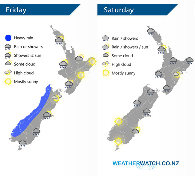
A front / southwest change moves northwards over the South Island during today reaching the lower North Island overnight. A northwest airflow covers the North Island today. A low pressure system forms and moves over Central New Zealand later on Saturday.
A shower or two for the western North Island today, expect plenty of long dry spells also. Sunny and warm along the east coast with highs getting into the low twenties. Rain moves into Wellington overnight. Heavy rain pushes into North Westland during today then easing late afternoon or evening, not easing about Buller till overnight. Early rain eases to showers about Southland and Otago, a dry start about Canterbury then afternoon showers / rain moves in with southerly winds. A few showers spread into Nelson during the afternoon then later in the evening / overnight expect widespread rain for Nelson / Marlborough.
Mostly cloudy with the odd shower for the upper / western North Island on Saturday, late afternoon or evening some rain pushes in from the west then eases overnight. The east coast has a mainly dry day however Wairarapa sees a few showers from afternoon. The upper South Island sees areas of rain or showers on Saturday, possibly heavy for a time late afternoon or evening then easing at night. Mostly sunny about the lower South Island, some cloud for coastal Otago with the risk of a late afternoon / evening shower.
By Weather Analyst Aaron Wilkinson – WeatherWatch.co.nz
Latest Video

Cold fronts continue, wind & rain for some Fri/Sat
Wet weather is moving over the North Island today, while the South Island has drier skies – ahead of another…
Related Articles
Cold fronts continue, wind & rain for some Fri/Sat
Wet weather is moving over the North Island today, while the South Island has drier skies – ahead of another…

Cold fronts vs high pressure
A cold front is moving up NZ today and into Tuesday, but will fall apart as it heads north and…

Wintry change coming for SI and lower NI
Some wet weather, along with a drop in temperatures, will move into the lower South Island later on Sunday and…

