InfoGraphic: The Big Picture for Friday / Saturday
29/11/2018 6:00pm

> From the WeatherWatch archives
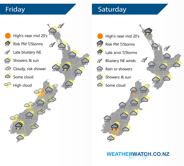
A large high to the southeast of the country and a low in the Tasman Sea directs a humid northeasterly airflow over New Zealand today. Humid northeasterlies continue on Saturday, becoming breezier with the low in the Tasman Sea moving closer.
Fairly dry for the western North Island this morning then the odd shower moves in by midday, rain gets into northern Northland in the evening. In the afternoon showers becoming heavy with a chance of thunderstorms about Taranaki and perhaps across to the Central North Island. Morning showers along the east coast then some afternoon sun breaks through. Fairly cloudy for the east coast of the South Island, there may be a morning drizzle patch near the coast then drying up. Inland areas in the east start dry then there is the risk of a shower in the afternoon or evening, staying mainly dry though. An isolated shower or two may crop up about the main divide in the afternoon then easing in the evening. Showers about Southland, Central Otago (especially in the west) and Fiordland once again may become heavy with thunderstorms in the afternoon then easing later in the evening.
Morning rain (possibly heavy) for Northland and Auckland then easing to showers, showers may become heavy with thunder from afternoon for Northland. Showers about the Waikato and Bay Of Plenty turning to rain by midday, rain may be heavy about the Bay Of Plenty then easing there in the evening. Northeasterlies blustery about Auckland. Cloudy areas along the east coast, chance of a shower, more likely from evening. A few showers in the west, morning rain about Taranaki then easing. Occasional showers or some rain at times for the West Coast and about Nelson, falls a bit more scattered the further east one travels. Once again late afternoon / evening isolated thunderstorms may develop about parts of Southland and Central Otago.
By Weather Analyst Aaron Wilkinson – WeatherWatch.co.nz
Latest Video

Cold weekend, frosts return with high pressure, then a low late next week
The subantarctic airflow spreads over NZ today/tonight and into Saturday, dropping temperatures nationwide. Snow flurries are possible today to lower…
Related Articles
Cold weekend, frosts return with high pressure, then a low late next week
The subantarctic airflow spreads over NZ today/tonight and into Saturday, dropping temperatures nationwide. Snow flurries are possible today to lower…

Wintry burst of weather: Snow, squally showers then sunshine & frosts
A polar change (another one!) arrives on Friday for the South Island and goes nationwide on Saturday, leaving NZ under…

Antarctic southerly for parts of NZ Fri & Sat
For the first time this year a southerly from off Antarctica is heading towards the South Island, followed by more…

