InfoGraphic: The Big Picture for Friday / Saturday
11/10/2018 6:00pm

> From the WeatherWatch archives
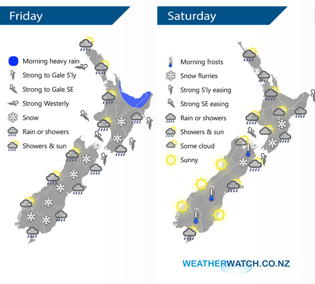
A low crosses over the country today moving in a west to east fashion letting in a strong cold southerly airflow which pushes northwards over both Islands during the day. A ridge pushes onto the South Island on Saturday however only for a time as font moves onto the far south by midday, strong south to southeasterly winds ease over the North Island during the day.
Early heavy rain eases about the upper North Island today then showers, some heavy with a chance of thunderstorms and hail pushes in from the west. These showers ease later in the afternoon. Rain or showers for the lower western North Island for much of the day, northerlies change around to the south in the afternoon becoming strong. Early rain clears for the eastern North Island then a cold southerly change pushes northwards bringing further rain. Snow flurries lower to 300m in the evening about Wellington and 500m further north for the Central North Island.
Rain or showers for most of the eastern South Island today with strong cold southerlies, snow flurries lower to low levels (200 to 100m) about Southland, Otago and Canterbury during the day. Flurries lower to 300m by evening about southern Marlborough. Morning rain along the West Coast then some sun may break through from afternoon.
Frosts return overnight/Saturday morning in the South Island – watch for possible black ice on the highways inland.
Rain or showers about the upper North Island on Saturday clearing by midday then some afternoon sun breaks through, winds from the southeast. Showers ease during the day along the east coast, clearing during the evening. Morning showers in the west Taranaki southwards clear then becoming mostly sunny in the afternoon. Snow flurries to 400m about the eastern North Island and Central Plateau for a time, perhaps down to 300m about the hills of Wellington and Wairarapa however at this level accumulations will be minimal if not non existent. Showers about Banks Peninsula northwards for the eastern South Island clear early in the morning then sunny areas develop, mainly dry for the rest of the South Island however another period of showers moves into Southland by midday then perhaps Otago by evening.
By Weather Analyst Aaron Wilkinson – WeatherWatch.co.nz
Latest Video

NZ: 8 Day outlook as gales & rain ease, high pressure builds
Damaging wind gusts and heavy rain will continue to affect some parts of the North Island and brushing Marlborough today…
Related Articles
NZ: 8 Day outlook as gales & rain ease, high pressure builds
Damaging wind gusts and heavy rain will continue to affect some parts of the North Island and brushing Marlborough today…

Pockets of hit & miss heavy rain, snow moves northwards
Low pressure continues to slowly move across the upper North Island and for some that will bring the sun out,…

Slow go for northern low & southern cold
For the next few days low pressure will crawl over the upper North Island, driving in rain as far south…

