InfoGraphic: The Big Picture for Friday / Saturday
27/09/2018 7:00pm

> From the WeatherWatch archives
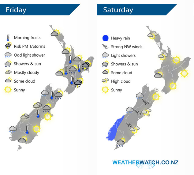
A large anticyclone brings fairly settled weather to most of New Zealand today, an upper pool of cold air may induce some unstable activity about the eastern North Island this afternoon. An anticyclone lies over much of the North Island on Saturday meanwhile expect northwesterlies for the South Island. A front moves onto the lower South Island around midday.
Fairly settled weather for most of the North Island today however from afternoon showers develop about the hills and ranges along the east coast, some of these showers may become heavy with thunderstorms and hail then clearing in the evening. Mostly cloudy for the western South Island, a patchy shower or two at times can be expected. Sunnier conditions out east, some cloud may develop about inland hills and ranges in the afternoon. A few isolated showers possible in the afternoon about hills and ranges of North Canterbury, Marlborough and Nelson.
Mainly settled for the North Island on Saturday, some cloud at times in the west. The South Island has mostly cloudy skies in the west bringing the odd shower, rain moves into Fiordland in the morning bringing heavy falls. Sunny in the east with increasing high cloud, some rain moves into the far south around midday.
By Weather Analyst Aaron Wilkinson – WeatherWatch.co.nz
Latest Video

NZ: 8 Day outlook as gales & rain ease, high pressure builds
Damaging wind gusts and heavy rain will continue to affect some parts of the North Island and brushing Marlborough today…
Related Articles
NZ: 8 Day outlook as gales & rain ease, high pressure builds
Damaging wind gusts and heavy rain will continue to affect some parts of the North Island and brushing Marlborough today…

Pockets of hit & miss heavy rain, snow moves northwards
Low pressure continues to slowly move across the upper North Island and for some that will bring the sun out,…

Slow go for northern low & southern cold
For the next few days low pressure will crawl over the upper North Island, driving in rain as far south…

