InfoGraphic: The Big Picture for Friday / Saturday
9/08/2018 7:00pm

> From the WeatherWatch archives
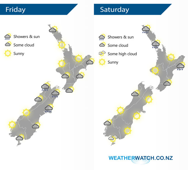
A high lies over over New Zealand today with a weak front moving over the upper South Island this morning then lower North Island in the afternoon. An anticyclone brings mainly settled conditions on Saturday for most of New Zealand, an easterly quarter airflow around the top of this high brings a few showers to Coromandel and Northland however.
A mix of sun and cloud for the upper North Island today, dry with light southwesterly winds. A mainly sunny morning in the east then cloud develops in the afternoon with the chance of a shower as light winds tend southerly. A few light showers possible from afternoon in the west also Taranaki southwards. A few showers affect Canterbury northwards in the south Island, easing from afternoon. Sunnier conditions further south with any morning cloud about Southland and Otago breaking away.
Mostly sunny for much of the North Island, an easterly quarter airflow brings a few showers for northern parts of Auckland and Northland however. Also about Hawkes Bay in the morning then perhaps Gisborne through till evening. The South Island has a mainly sunny and settled day.
By Weather Analyst Aaron Wilkinson – WeatherWatch.co.nz
Latest Video

Cold weekend, frosts return with high pressure, then a low late next week
The subantarctic airflow spreads over NZ today/tonight and into Saturday, dropping temperatures nationwide. Snow flurries are possible today to lower…
Related Articles
Cold weekend, frosts return with high pressure, then a low late next week
The subantarctic airflow spreads over NZ today/tonight and into Saturday, dropping temperatures nationwide. Snow flurries are possible today to lower…

Wintry burst of weather: Snow, squally showers then sunshine & frosts
A polar change (another one!) arrives on Friday for the South Island and goes nationwide on Saturday, leaving NZ under…

Antarctic southerly for parts of NZ Fri & Sat
For the first time this year a southerly from off Antarctica is heading towards the South Island, followed by more…

