InfoGraphic: The Big Picture for Friday / Saturday
5/07/2018 7:00pm

> From the WeatherWatch archives
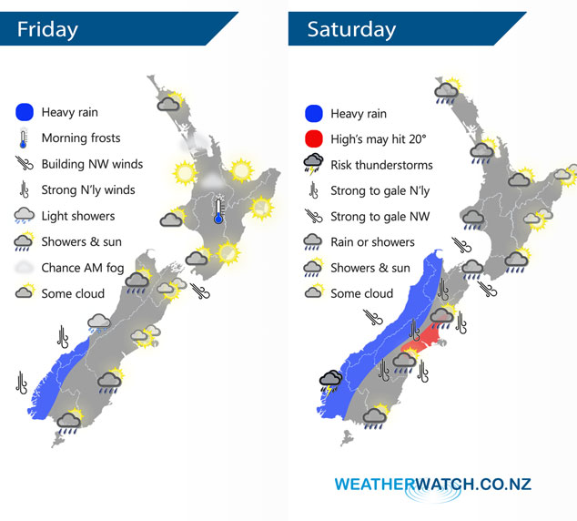
A northwesterly airflow lies over most of New Zealand today, strengthening overnight. The upper North Island has a ridge of high pressure. A strong northwesterly airflow lies over New Zealand on Saturday, a cold front moves northwards over the South Island during the day reaching the lower North Island in the evening.
A mostly sunny day for the upper North Island today, a chance of some morning fog also. The lower North Island has good weather also however from afternoon some cloud moves in Taranaki southwards and brings the low risk of a shower. Rain is heavy at times for South Westland during the day. High cloud in the east with some scattered rain spreading from the west at times about Southland and Otago, especially afternoon.
Thickening cloud for the western North Island on Saturday, the odd patchy showers spreads into western Waikato northwards from afternoon. Drier in the east with some high cloud. Heavy rain for the West Coast of the South Island eases from afternoon, thunderstorms may make their presence felt about Fiordland. In the east expect morning spots of rain to clear then sunny weather for the afternoon, high’s in Canterbury may even nudge twenty degrees. Marlborough and Nelson stay cloudy all day however with showers or scattered rain, especially late afternoon / evening.
By Weather Analyst Aaron Wilkinson – WeatherWatch.co.nz
Latest Video

NZ: 8 Day outlook as gales & rain ease, high pressure builds
Damaging wind gusts and heavy rain will continue to affect some parts of the North Island and brushing Marlborough today…
Related Articles
NZ: 8 Day outlook as gales & rain ease, high pressure builds
Damaging wind gusts and heavy rain will continue to affect some parts of the North Island and brushing Marlborough today…

Pockets of hit & miss heavy rain, snow moves northwards
Low pressure continues to slowly move across the upper North Island and for some that will bring the sun out,…

Slow go for northern low & southern cold
For the next few days low pressure will crawl over the upper North Island, driving in rain as far south…

