InfoGraphic: The Big Picture for Friday / Saturday
26/04/2018 7:00pm

> From the WeatherWatch archives
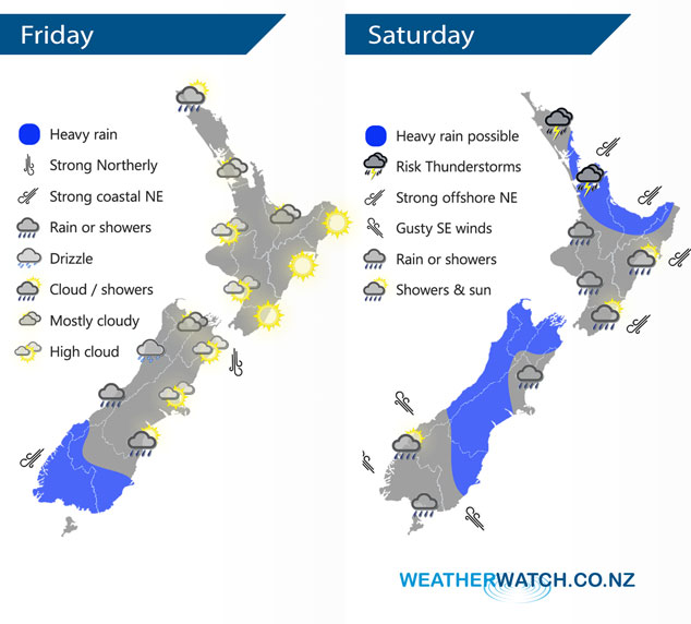
A northerly airflow increases today with a front moving onto the lower South Island this morning, meanwhile a low sits in the Tasman Sea. This low moves closer towards New Zealand on Saturday and draws a northeasterly airflow over the North Island and a southerly airflow over the South Island. Expect plenty of unsettled weather with areas of heavy rain likely, especially for the North Island.
A northerly airflow increases today, there is a chance of morning fog for the Waikato as a ridge of high pressure hangs on first thing. Heavy rain pushes into Fiordland in the afternoon then moving around into Southland and Otago through till evening, rain about Southland and Otago won’t be overly heavy but the intensity should pick up later in the day / overnight.
Wet and unsettled for most of New Zealand on Saturday, rain for the South Island while heavy doesn’t look as intense as falls further north for Northland through to Bay Of Plenty as a front moves southwards over the upper North Island during the day. Rain about the Bay Of Plenty may become fairly torrential in the evening / overnight for a time. Watch for a chance of thunderstorms in the east also between Coromandel and eastern Northland.
By Weather Analyst Aaron Wilkinson – WeatherWatch.co.nz
Latest Video

NZ 7 day forecast: Showers, temp changes and heavy West Coast rain
NZ has a fairly messy forecast over the next 7 days, but the main feature will be heavy rain on…
Related Articles
NZ 7 day forecast: Showers, temp changes and heavy West Coast rain
NZ has a fairly messy forecast over the next 7 days, but the main feature will be heavy rain on…

Cold fronts continue, wind & rain for some Fri/Sat
Wet weather is moving over the North Island today, while the South Island has drier skies – ahead of another…

Cold fronts vs high pressure
A cold front is moving up NZ today and into Tuesday, but will fall apart as it heads north and…

