
> From the WeatherWatch archives
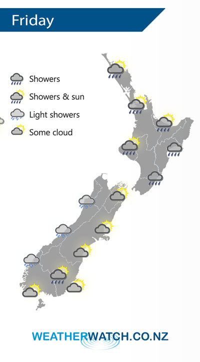
A front breaks up over the North Island on Friday as it moves northwards, anticyclonic conditions building elsewhere otherwise.
Morning showers clear for most of the western North Island then sunny areas increase with southeasterly winds, the odd shower may hang about Northland through till evening. Early rain along the east coast eases to showers then long dry spells developing from afternoon, winds cool from the south.
Mostly cloudy for the West Coast of the South Island, chance of a light shower or two especially about Buller. Cloudy areas and occasional sun elsewhere, chance of an isolated shower late afternoon / evening about inland Otago.
By Weather Analyst Aaron Wilkinson – WeatherWatch.co.nz
Latest Video

Cold weekend, frosts return with high pressure, then a low late next week
The subantarctic airflow spreads over NZ today/tonight and into Saturday, dropping temperatures nationwide. Snow flurries are possible today to lower…
Related Articles
Cold weekend, frosts return with high pressure, then a low late next week
The subantarctic airflow spreads over NZ today/tonight and into Saturday, dropping temperatures nationwide. Snow flurries are possible today to lower…

Wintry burst of weather: Snow, squally showers then sunshine & frosts
A polar change (another one!) arrives on Friday for the South Island and goes nationwide on Saturday, leaving NZ under…

Antarctic southerly for parts of NZ Fri & Sat
For the first time this year a southerly from off Antarctica is heading towards the South Island, followed by more…

