InfoGraphic: Next 3 days – colder as Donna’s remnants depart New Zealand
11/05/2017 10:57pm

> From the WeatherWatch archives
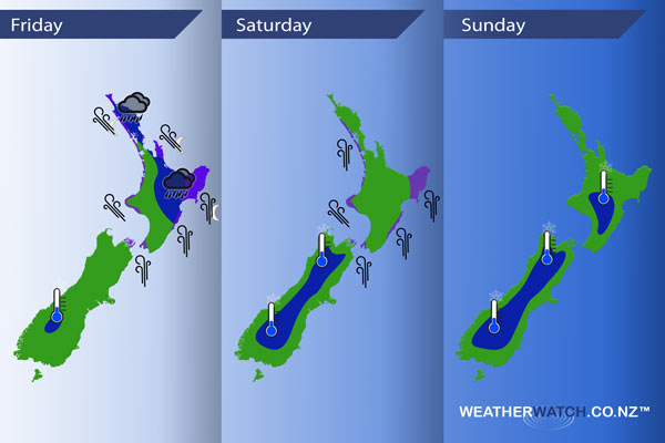
A southerly quarter airflow spreads over much of the country today while ex TC Donna moves southeast just off the northeastern side of the North Island during the day, a high pushes in on Saturday while ex TC Donna moves away to the east. Anticyclonic conditions for most of New Zealand on Sunday.
Friday
Blue – Heavy rain about northeastern parts of the North Island eases this morning, heavy / torrential falls about East Cape and Gisborne may not ease till overnight.
Purple – South to southeasterly winds strengthen during the day through Cook Strait and many North Island coastal areas, winds may gust to gale especially about Gisborne, East Cape and the Coromandel from evening.
Saturday
Blue – A cold start about the inner South Island reaching down to 0 to -2 degrees celsius. -3 to -4 isn’t out of the question for some parts of inland Otago and inland South Canterbury.
Purple – Strong south to southeasterly winds ease over the North Island during the day, the strongest winds will be about coastal Gisborne / East Cape with gales likely. Strong southerlies may remain about coastal Gisborne / East Cape through the night and then finally easing on Sunday.
Sunday
Blue – A mainly settled day however a cold start especially inland of around -3 to 0 degrees celsius for the shaded areas below.
– Please note, the idea behind this update is to focus on the main weather highlights, which is why not all regions are mentioned.
For specific 10 day information for your city, town, rural community or island please see the 1500 forecasts on our homepage!
– Aaron Wilkinson, WeatherWatch.co.nz
Latest Video

Cold weekend, frosts return with high pressure, then a low late next week
The subantarctic airflow spreads over NZ today/tonight and into Saturday, dropping temperatures nationwide. Snow flurries are possible today to lower…
Related Articles
Cold weekend, frosts return with high pressure, then a low late next week
The subantarctic airflow spreads over NZ today/tonight and into Saturday, dropping temperatures nationwide. Snow flurries are possible today to lower…

Wintry burst of weather: Snow, squally showers then sunshine & frosts
A polar change (another one!) arrives on Friday for the South Island and goes nationwide on Saturday, leaving NZ under…

Antarctic southerly for parts of NZ Fri & Sat
For the first time this year a southerly from off Antarctica is heading towards the South Island, followed by more…

