Hurricane Patricia: Latest Maps (6) + report from hurricane hunter flight through eyewall
23/10/2015 10:41pm

> From the WeatherWatch archives
WeatherWatch.co.nz closely monitors many Pacific Ocean storms. Today we are monitoring something historic – a storm that rapidly grew overnight into a Category 5 storm with air pressure falling and winds increasing to levels so intense it made Patricia the most intense hurricane to ever be recorded (hurricanes form in the western hemisphere).
We have more details about Patricia’s record breaking status on our homepage.
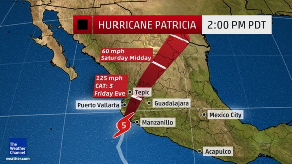
Below are the latest maps we have on Category 5 Patricia – and further below the technical report from NOAA, after hurricane hunters flew through the eye of the storm a short time ago to measure air pressure.
Thankfully Patricia is small in size – meaning the area with the most damaging winds is small too – but winds may be catastrophic.
Please note as of 12:20pm NZT Patricia had made landfall in Mexico.
Images via our partners at Wunderground/Weather.com
===


====
A NOAA hurricane hunter aircraft reported that Patricia changed

little in intensity through about 1800 UTC.  The aircraft measured

192 kt flight-level winds at 700 mb in the southeastern eyewall,

with a 166 kt surface wind estimate from the stepped frequency

microwave radiometer.  The central pressure estimated from an eye

dropsonde was 879 mb.  Since that time, the eye has become

cloud-filled, and data from the plane suggest the formation of an

outer wind maximum, with decreasing winds in the eyewall, and an

increasing central pressure.  All of these indicate that the

hurricane is weakening.  The initial intensity is reduced to 165 kt,

and this could be generous.  Patricia is expected to remain a

category 5 hurricane until landfall in southwestern Mexico in a few

hours. After landfall, a combination of the mountainous terrain of

Mexico and increasing shear should cause the cyclone to rapidly

weaken, with the system likely to dissipate completely after 36

hours, if not sooner.


Patricia is now moving north-northeastward with an initial motion

of 015/12.  The cyclone is recurving into the westerlies between a

mid-level anticyclone to its east and a deep-layer trough over

northwestern Mexico and the southwestern U. S., And a faster motion

toward the north-northeast is expected for the rest of the cyclone's

life.  The new forecast track is shifted a little to the east of the

previous track based on the initial position and motion. It lies

near the center of the guidance envelope at 12 hours and little to

the left of the center after that time.


The global models continue to depict the development of a cyclone

near the Texas coast over the weekend.  This system should be

non-tropical in nature.  However, this cyclone is expected to draw

significant amounts of moisture from Patricia's remnants, and could

result in locally heavy rainfall over portions of the northwestern

Gulf of Mexico coastal area within the next few days.  Refer to

statements from local National Weather Service forecast offices for

details.


Key messages:


1.  Confidence is high that Patricia will make landfall in the

Hurricane Warning area along the coast of Mexico as an extremely

dangerous category 5 hurricane during the next few hours.

Preparations to protect life and property in the Hurricane Warning

area should have been completed, or rushed to completion, as

tropical storm conditions are spreading across the area and

hurricane conditions are about to occur.  Residents in low-lying

areas near the coast in the Hurricane Warning area should evacuate

immediately, since the storm surge could be catastrophic near and to

the east of where the center makes landfall.


2.  In addition to the coastal impacts, very heavy rainfall is

likely to cause life-threatening flash floods and mud slides in the

Mexican states of Jalisco, Colima, michoacan and Guerrero continuing

into Saturday.


3. The NOAA hurricane hunter aircraft reports that at this time, the

category 5 winds are occurring over a very small area near the

center - about 15 miles across.


Forecast positions and Max winds


Init  23/2100z 18.9n 105.2w  165 kt 190 mph

 12h  24/0600z 21.1n 104.2w  110 kt 125 mph...inland

 24h  24/1800z 24.0n 102.2w   50 kt  60 mph...inland

 36h  25/0600z 26.9n 100.0w   20 kt  25 mph...Post-trop/remnt low

 48h  25/1800z...dissipated


- WeatherWatch.co.nz with Wunderground
Latest Video

Polar airflows set to bring cold weekend to NZ
Nor-west winds will be building over parts of NZ going into Thursday with rain on the West Coast becoming heavy…
Related Articles

ClimateWatch: JULY outlook & what El Niño means for NZ
El Niño is officially here and still getting stronger in the months ahead, but it’s harder to notice its effects…

ClimateWatch: JUNE outlook as El Niño continues to build
June has kicked off in NEUTRAL again as far as El Niño is concerned, but it is expected to form…

ClimateWatch: May outlook & El Niño discussion
Everyone is talking about El Niño so in this month’s update we discuss when it may be forming and what…

