Hotter day in the east today, cooler in the south (x4 Maps)
24/09/2017 9:52pm

> From the WeatherWatch archives
A warm nor’west flow over the country today will boost temperatures into the mid to late 20s this afternoon in the east of the North Island while Cantebury and Marlborough feel the warmth further south, in the low 20s.
Around dawn this morning parts of Canterbury were already in the low 20s while parts of Hawkes Bay were already at 24 degrees (near Wairoa).
The day is only just getting started with main centres like Napier, Hastings and Gisborne all likely to reach the mid 20s, possibly late 20s this afternoon.
Not everyone will get the heat – as you can see the areas with the orange shading are most likely to get into the mid to late 20s today. If you live on the western coastline the cloud from the Tasman Sea will be making for a cooler, gloomier day (like Auckland and parts of Northland). Also, while Waikato has the chance to reach the low to mid 20s today, the gloomy clouds from the Tasman may limit this. Best chances for heat today are in the east, over the ranges where it will be sunnier with a north to north west wind flow.
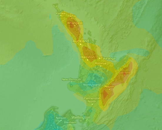 – Forecast Temperature map for 4pm today shows hottest weather in localised pockets (orange) / Weathermap
A cold front is moving up the South Island and has already passed Dunedin dropping temperatures there. This cold change is also sparking a few thunderstorms in the west out at sea and will only track very slowly northwards into the North Island over the next 24 hours or so.


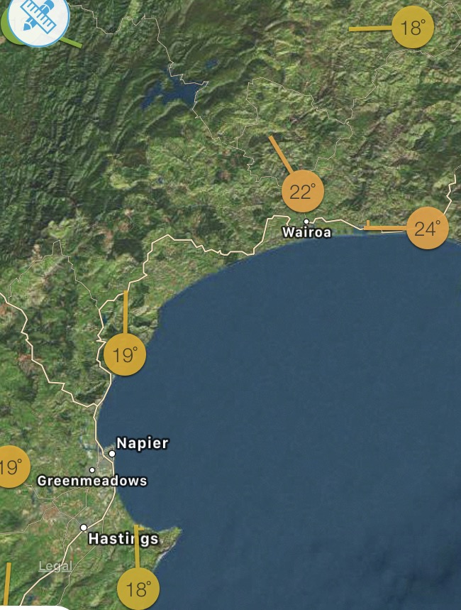
– Maps as of 10:45am courtesy WeatherWatch & IBM/TWC
– WeatherWatch.co.nz
Latest Video

Cold weekend, frosts return with high pressure, then a low late next week
The subantarctic airflow spreads over NZ today/tonight and into Saturday, dropping temperatures nationwide. Snow flurries are possible today to lower…
Related Articles
Cold weekend, frosts return with high pressure, then a low late next week
The subantarctic airflow spreads over NZ today/tonight and into Saturday, dropping temperatures nationwide. Snow flurries are possible today to lower…

Wintry burst of weather: Snow, squally showers then sunshine & frosts
A polar change (another one!) arrives on Friday for the South Island and goes nationwide on Saturday, leaving NZ under…

Antarctic southerly for parts of NZ Fri & Sat
For the first time this year a southerly from off Antarctica is heading towards the South Island, followed by more…

