Heavy rain, strong winds, sunshine, snow and swells… your weekend weather (+8 Maps)
18/07/2018 11:08pm

> From the WeatherWatch archives
A burst of rough weather is about to move into New Zealand this weekend and our mountains and ranges will create stronger winds, heavier rain for many, but also sunshine and warmth for others.
On Thursday a small areas of heavy downpours lies just off the Auckland and Waikato coastlines over the eastern Tasman Sea. There is a chance a few thunderstorms will develop today amongst this cluster of downpours, most will be offshore. There is some chance we may get a thunderstorms over land in these areas. WeatherWatch.co.nz says the main area of downpours was lying out at sea as of 7:45am but drift in (tracking eastwards) this morning.
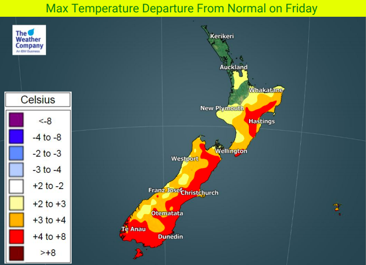
On Friday high pressure moves away from the country, slowly allowing a NW wind to develop in the South Island and this will help push temperatures up by several degrees above normal for some in the east and south.
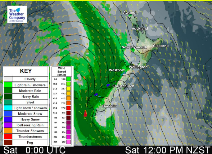
On Saturday, rain and snow are intensifying. Locally heavy downpours will move up the West Coast (watch for rain warnings) and and burst of snow is expected on the Southern Alps. Strong NW winds (watch for potential wind warnings) will push into inland and eastern areas with gales possible in exposed areas. These strong winds peak on Saturday as they move into the Cook Strait and lower North Island. Generally speaking, while strong, most places are below damaging threshold. Be prepared for isolated power cuts just in case.
Big waves will also be generated along the West Coast.
On Sunday the warmer than normal conditions across the country will start to drop.
By Monday and Tuesday of next week most places will be cooler, but ‘back to normal’ for late July.
WeatherWatch.co.nz says milder than average weather is still likely to return again mid to late next week.


– WeatherWatch.co.nz
Latest Video

Cold weekend, frosts return with high pressure, then a low late next week
The subantarctic airflow spreads over NZ today/tonight and into Saturday, dropping temperatures nationwide. Snow flurries are possible today to lower…
Related Articles
Cold weekend, frosts return with high pressure, then a low late next week
The subantarctic airflow spreads over NZ today/tonight and into Saturday, dropping temperatures nationwide. Snow flurries are possible today to lower…

Wintry burst of weather: Snow, squally showers then sunshine & frosts
A polar change (another one!) arrives on Friday for the South Island and goes nationwide on Saturday, leaving NZ under…

Antarctic southerly for parts of NZ Fri & Sat
For the first time this year a southerly from off Antarctica is heading towards the South Island, followed by more…

