Heavy frosts this weekend for some, colder Sunday for many regions
16/08/2019 10:00pm

> From the WeatherWatch archives
Heavy frosts down to -8C are in the forecast with potentially some of the heaviest of the year tonight and tomorrow night thanks to a cold southerly followed by a large high.
The big high will lock in the cold air tonight over the South Island then much of the country on Sunday night.
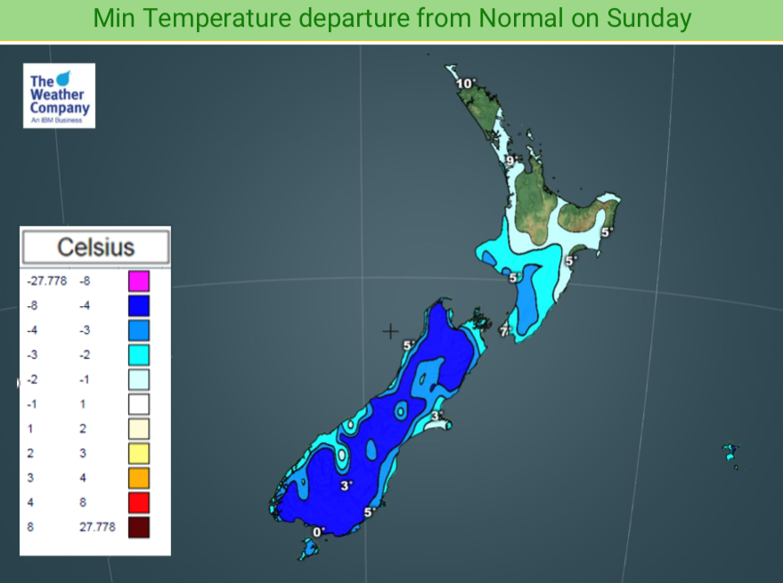
Overnight lows tonight may drop as low as -8C in alpine areas. Inland parts through Otago, Southland and Canterbury have the highest risk of frost tonight.
Currently WeatherWatch.co.nz is forecasting Queenstown will drop down to -5 tonight, while Tekapo has -6C. Alexandra and Cromwell look to drop to around -3. Tomorrow night more of Canterbury looks to be getting colder, for example tonight drops to around +1C in Darfield but -4C there tomorrow night. The frosty weather may not make it into coastal areas.
The North Island’s cold change moves up the island across Saturday and tonight and over Sunday. The high pressure system expands and increases over the North Island on Sunday and by night time will bring lighter winds and lower temperatures. Frosty weather is possible around some parts of Waikato on Monday morning. Rural parts of South Auckland are on the borderline where it lifts up to +3C. A slight breeze in the north may keep overnight lows up a few degrees.
Frosts overnight Sunday/Monday morning will be possible in an number of inland, sheltered, parts of both islands.
Warmer northerlies return on Monday to the South Island and across Tuesday in the North Island.

– WeatherWatch.co.nz
Comments
Latest Video

Cold weekend, frosts return with high pressure, then a low late next week
The subantarctic airflow spreads over NZ today/tonight and into Saturday, dropping temperatures nationwide. Snow flurries are possible today to lower…
Related Articles
Cold weekend, frosts return with high pressure, then a low late next week
The subantarctic airflow spreads over NZ today/tonight and into Saturday, dropping temperatures nationwide. Snow flurries are possible today to lower…

Wintry burst of weather: Snow, squally showers then sunshine & frosts
A polar change (another one!) arrives on Friday for the South Island and goes nationwide on Saturday, leaving NZ under…

Antarctic southerly for parts of NZ Fri & Sat
For the first time this year a southerly from off Antarctica is heading towards the South Island, followed by more…


Guest on 17/08/2019 4:02am
why is this when you said winter would be over by mid august
WW Forecast Team on 17/08/2019 4:24am
Didn’t say winter was over in mid August, we said that the coldest period is July up to mid-August (historically) so once you go beyond mid August (for example about one week from now) then time is running out for major cold changes to linger for more than a day or two simply due to the days getting longer and nights shorter. In fact the cold event this weekend is only lasting 48 hours for most places before mild northerlies kick in.
We also said major frosts and snow events can linger into October – but winter is defined by a period of decay and dormancy so with warmer than average days still in the mix for us (much more of them than colder than normal days) along with plants already showing signs of spring and pasture growth rates and soil temperatures all above normal for this time of year means winter is struggling to be ‘normal’ this year, even with the colder snaps right now.
Cheers
WW