Heavy downpours, isolated thunderstorms possible for parts of NZ next few days (+4 Maps)
21/03/2018 10:28pm

> From the WeatherWatch archives
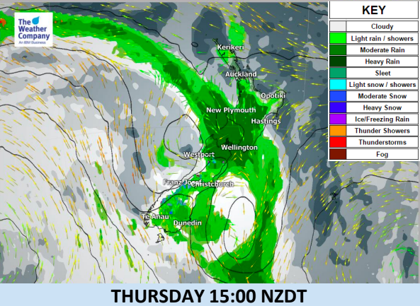
A cold front with a broad band of rain will move to the North Island from today and bring showers and
even some isolated thunderstorms. Because of a large high pressure parked to the east, a low has formed off the west
coast and will stay for next few days, causing unstable conditions mainly to the northern and central North
Island.
WeatherWatch.co.nz says this low is fairly weak but has enough energy to make for very localised but intense downpours.
The video below was captured by Sam James (@SamJames) on Thursday morning. “Torrential rain in Nelson/Richmond the last 30mins!!! Manholes open, streets with surface flooding” he told WeatherWatch.co.nz a short time ago.
Torrential rain in Nelson/Richmond the last 30mins!!! Manholes open, streets with surface flooding. @WeatherWatchNZ pic.twitter.com/yQdZ0lMVcq
— Sam James (@samjamez) March 21, 2018
Main features:
- Thursday afternoon heavy downpours and isolated thunderstorms are possible in the central part of the North Island, ahead of the front.
- Several hours of rainfall of 10-20mm/h or heavier is possible in some locations, this may cause very localised flooding – drive witih extreme care.
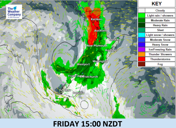
- The front will be activated again due to supplied energy from the humid and warm northeasterly winds around the high pressure system merging into this low.
- On Friday, showers and (isolated) thunderstorms with wind gusts along the front are likely in Taranaki, Nelson and northern Westland.
- At the weekend, the area of showers and any isolated remaining thunderstorms around the front will be over the northern and eastern part of the North Island.
- Recurrent afternoon thunderstorms are possible in Northland and Auckland until Sunday but can be a bit hard to lock in due to the narrow shape of northern NZ (so may form offshore instead – one to keep an eye on).
- Please note the red thunderstorm risk areas (in the maps below) highlight the areas most exposed to isolated thunderstorms – not everyone within those red highlighted areas will have thunder, it’s just the highest risk zone for them to form.


– WeatherWatch.co.nz (an IBM business partner).
Latest Video

More heavy rain, snow – but large dry areas, especially as we go into the long weekend
Heavy rain will continue for parts of Canterbury and Marlborough over the next day or two and it will gradually…
Related Articles
More heavy rain, snow – but large dry areas, especially as we go into the long weekend
Heavy rain will continue for parts of Canterbury and Marlborough over the next day or two and it will gradually…

Large low brings rain, downpours & some snow – gets colder as the week progresses
Low pressure will cross the upper North Island in the days ahead and that set-up actually pushes more heavy rain…

WeatherWatch App launches real-time local lightning tracker!
A bolt out of the blue! WeatherWatch has launched a live, real-time lightning tracker, enabling Kiwis to gain access to data provided by the…

